 Filter: Categories of Wisconsin Historical Images
Filter: Subject of Trails
Filter: Subject of industries
Filter: Categories of Wisconsin Historical Images
Filter: Subject of Trails
Filter: Subject of industries
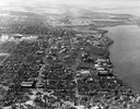
| Date: | 1946 |
|---|---|
| Description: | Aerial view of the University of Wisconsin campus with Lake Mendota on the right. |
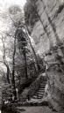
| Date: | 1945 |
|---|---|
| Description: | Tower Hill State Park trail leading to the top of the shot tower shaft. |
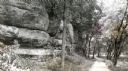
| Date: | 1945 |
|---|---|
| Description: | Tower Hill State Park trail to the top of the shot tower shaft. |

| Date: | 1940 |
|---|---|
| Description: | Rear view of a man pulling logs with an International TracTracTor (crawler tractor) on a logging road in a forest. |

| Date: | 1940 |
|---|---|
| Description: | Seldon Starcher, owner and operator of an International TD-6 Diesel TracTracTor (crawler tractor), uses his tractor both in logging and oil field work. He ... |
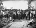
| Date: | |
|---|---|
| Description: | A few dozen men stand on and around a sandy path surrounded by low shrubbery. They are wearing work clothes, and some of them are carrying bowls filled wit... |

| Date: | |
|---|---|
| Description: | View uphill of a team of oxen with a wagon stacked with lumber. In the background, men gather outside a general store located in the Raton Mountains, betwe... |

| Date: | |
|---|---|
| Description: | View of a trail through the forest on land owned by Nature Lovers Paradise resort on Jackson Lake. The text describing the photograph says, "The trail lead... |

| Date: | 1837 |
|---|---|
| Description: | This map shows the townships, roads, trails, natural land forms, vegetation, mill sites and lead and copper deposits in the Wisconsin Territory at the time... |

| Date: | 1952 |
|---|---|
| Description: | This 1952 map of the northern parts of Bayfield and Douglas counties, Wisconsin, shows points established by E.T. Sweet in 1877, road points confirmed by S... |

| Date: | 1960 |
|---|---|
| Description: | This manuscript map of Taylor County, Wisconsin, shows the township and range grid, lakes and streams, "Chippewa trails, Indian trails" Indian villages and... |

| Date: | 03 20 1986 |
|---|---|
| Description: | View of Quarry Drive, a sunken path lined with trees, near Mendota Heights. Branches and stones obstruct the pathway. |

| Date: | 1949 |
|---|---|
| Description: | This pictorial map shows the United States west of the Mississippi, including Indian Tribes, historic trails, forts, trading posts, mountain ranges, lakes ... |

| Date: | 1860 |
|---|---|
| Description: | This map shows roads, trails, and railroads throughout Nebraska, Arkansas, Missouri, Kansas, Illinois, and Utah, including the Salt Lake City & California ... |

| Date: | 1900 |
|---|---|
| Description: | This photostat map was probably originally created in 1835 and shows in addition to private claims, mills, roads, and trails. Green Bay and the Fox River a... |

| Date: | 1900 |
|---|---|
| Description: | This map shows logging roads, railroads with spur lines, trails, rapids, lumber camps, Indian villages, summer resort, lakes, rivers, and ponds. |

| Date: | 1794 |
|---|---|
| Description: | Extremely detailed map of the south-eastern states, south from Virginia and east of the Mississippi River. It shows roads and paths, cities, towns, forts, ... |

| Date: | 1950 |
|---|---|
| Description: | View towards man using a TD-24 to load logs onto a truck. Mountains are in the background. Subject: "TD-24 — Lumbering." Where Taken: "Pac." Information wi... |

| Date: | 1950 |
|---|---|
| Description: | View down trail towards a man using a TD-24. Mountains are in the background. Subject: "TD-24 — Lumbering." Where Taken: "Pac." Information with photograph... |

| Date: | 1960 |
|---|---|
| Description: | A man is running his dog on a trail in an old lead mining area. The trees are bare and fallen leaves are covering the ground. |
If you didn't find the material you searched for, our Library Reference Staff can help.
Call our reference desk at 608-264-6535 or email us at: