 Filter: Categories of Wisconsin Historical Images
Filter: Subject of Surveying
Filter: Subject of military art and science
Filter: Categories of Wisconsin Historical Images
Filter: Subject of Surveying
Filter: Subject of military art and science

| Date: | 1848 |
|---|---|
| Description: | Map of Wisconsin and a portion of Minnesota showing the township surveys in progress in portions of the Saint Croix River region and in central Wisconsin a... |

| Date: | 1867 |
|---|---|
| Description: | This map of the battlefield on the North Anna River at Hanover Junction illustrates the Union positions in blue and Confederate positions in red. Roads, ra... |

| Date: | 1860 |
|---|---|
| Description: | A survey map of Wisconsin, southeastern Minnesota, and northern Iowa, showing the status of surveys, rivers, and lakes. The map also shows the locations of... |
| Date: | 08 1966 |
|---|---|
| Description: | Front cover of a report by The Wisconsin Survey Research Laboratory on their public opinion research regarding Wisconsinites' attitudes toward the Vietnam ... |
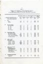
| Date: | 08 1966 |
|---|---|
| Description: | Compiled data regarding attitudes about the United States' involvement in Vietnam in 1966 broken down by gender, age, education level, household income, po... |
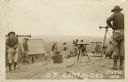
| Date: | |
|---|---|
| Description: | Photographic postcard view of a group of surveyors working on a hilltop at Camp McCoy. Caption reads: "O. P. Camp McCoy, Sparta, Wis." |
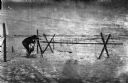
| Date: | 1918 |
|---|---|
| Description: | Outdoor view of a U.S. Army Engineer topographer wearing skis while in the process of surveying land. The engineer is standing next to a barbed wire obstac... |

| Date: | 1918 |
|---|---|
| Description: | Outdoor view of a U.S. Army Engineer topographer wearing skis while using a tripod stand to write. The engineer is standing next to a barbed wire obstacle ... |

| Date: | 04 11 1940 |
|---|---|
| Description: | This blue line print map shows survey monument markers by type and industrial buildings and covers part of the lower Fox River and East River. The map incl... |

| Date: | 1982 |
|---|---|
| Description: | A segment of the trunk of a pine bears the scars of a "blaze" carved with an ax and bearing the inscription: "XIX T. J. Cram, D. Houghton Aug 11, 1841." C... |
If you didn't find the material you searched for, our Library Reference Staff can help.
Call our reference desk at 608-264-6535 or email us at: