 Filter: Categories of Wisconsin Historical Images
Filter: Subject of Superior, Lake
Filter: Subject of recreation areas
Filter: Categories of Wisconsin Historical Images
Filter: Subject of Superior, Lake
Filter: Subject of recreation areas

| Date: | 1890 |
|---|---|
| Description: | Bird's-eye map of Ashland, viewed from Lake Superior, with insets of Prentice Park and Fishery. Population 16,000. Increase in Ten Years, 11,000. |
| Date: | 1979 |
|---|---|
| Description: | Senator Gaylord Nelson, Dave Obey, and Secretary of the Interior Cecil Andrus, walk along a beach with a park ranger during a tour of the Apostle Islands. ... |
| Date: | 1932 |
|---|---|
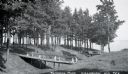
| Description: | View of two wooden foot bridges in Memorial Park. In the background are the waters of Chequamegon Bay in Lake Superior. Picnic tables are among the trees. ... |
| Date: | 1935 |
|---|---|
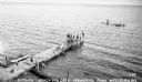
| Description: | Boys and girls wearing bathing suits standing, swimming, or diving off of a large wooden dock into Chequamegon Bay, Lake Superior on the beach at Memorial ... |
| Date: | 1935 |
|---|---|
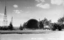
| Description: | View of the Ashland Band Shell with benches, trees, and what is today Highway 2 in the foreground. On the left is a large metal tower, and in the backgroun... |

| Date: | 1939 |
|---|---|
| Description: | This nine-part map from the U.S. Bureau of Public Roads identifies federal and state highways in Wisconsin by pavement type. County, forest, park, and publ... |

| Date: | 1944 |
|---|---|
| Description: | This nine-part map from the U.S. Bureau of Public Roads identifies federal and state highways in Wisconsin by pavement type. County, forest, park, and publ... |

| Date: | 07 2001 |
|---|---|
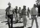
| Description: | David Obey poses with Park Ranger Geoffrey Smith on the left and Martin Hanson on the right. They are standing on the beach with water and land in the back... |

| Date: | 01 1856 |
|---|---|
| Description: | This map shows lots, lots appropriated for churches and schools, streets, parks, court house, and land to be appropriated for railroad depots. An inset map... |

| Date: | 1900 |
|---|---|
| Description: | This map shows streets, railroads, dock and harbor lines, and parks. The map includes population tables for 1880, 1890, 1900. |

| Date: | 1939 |
|---|---|
| Description: | This illustrated map shows counties, highways, rivers, roads, present and proposed state parks and forests, proposed state parkways, proposed state monumen... |

| Date: | 1921 |
|---|---|
| Description: | This map shows counties, roads, Lake Superior, Lake Michigan, and portions of surrounding states. Included is an index to cities, villages and other places... |

| Date: | 1996 |
|---|---|
| Description: | This map shows roads, lakes, points of interest including colleges, trails, historic communities and sites, museums, and parks. Also included are descripti... |

| Date: | 1919 |
|---|---|
| Description: | Narrow red lines show principal secondary highways. Green circles shows points of historical interest. Green triangles show Indian mounds and Indian villag... |

| Date: | 1933 |
|---|---|
| Description: | This map shows the state trunk highway system and county trunk highways. This map show surface type on state and county trunk highways and the locations of... |

| Date: | 1925 |
|---|---|
| Description: | This map shows road surfacing, camp sites, rivers, lakes, county boundaries, and cities. Original caption reads, "Compliments Hotel Witter Tour Information... |

| Date: | 1933 |
|---|---|
| Description: | This road map shows automobile routes across Wisconsin as well as portions of Illinois, Minnesota, Iowa and Michigan. Lakes Michigan, Superior and Winnebag... |

| Date: | 1933 |
|---|---|
| Description: | This map contains automobile routes across Wisconsin and portions of Illinois, Iowa, Minnesota and Michigan as well. The state borders are clearly defined... |

| Date: | 1935 |
|---|---|
| Description: | This colored road map comes with a map legend and explanation, as well as an index of cities and towns (and their populations) in Wisconsin. Information ab... |

| Date: | 1936 |
|---|---|
| Description: | This colored road map shows automobile roads in Wisconsin as well as portions of Michigan, Iowa, Minnesota, and Illinois. U.S. numbered highways are shown ... |
If you didn't find the material you searched for, our Library Reference Staff can help.
Call our reference desk at 608-264-6535 or email us at: