Filter: Categories of Wisconsin Historical Images
Filter: Subject of Superior, Lake
Filter: Subject of human settlements
Filter: County of Bayfield
Filter: Categories of Wisconsin Historical Images
Filter: Subject of Superior, Lake
Filter: Subject of human settlements
Filter: County of Bayfield

| Date: | 1886 |
|---|---|
| Description: | Bird's-eye view of Bayfield, county seat of Bayfield County. On the lower left side is an inset for Bayfield and the Apostle Islands. |

| Date: | 1886 |
|---|---|
| Description: | Bird's-eye map of Washburn on Lake Superior. There is an inset of Washburn, Chequamagon and the Apostle Islands. |

| Date: | 1896 |
|---|---|
| Description: | Bird's-eye view of Washburn, with twenty vignettes around side, water in foreground with docks and lumber corral. Thirty-three locations identified in key ... |

| Date: | 1910 |
|---|---|
| Description: | Bird's-eye view looking east, with Washburn Harbor at center and Chequamegon Bay in Lake Superior covering most of the upper image. Streets with buildings... |
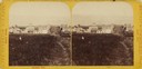
| Date: | 1875 |
|---|---|
| Description: | Stereograph view of Bayfield with a sawmill in the foreground. |
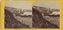
| Date: | 1876 |
|---|---|
| Description: | Stereograph view of Lake Superior scenery and downtown area. |

| Date: | 1858 |
|---|---|
| Description: | Front cover of a guide book describing Bayfield and an account of a pleasure tour to Lake Superior. The title is surrounded by a decorative border with flo... |

| Date: | 1880 |
|---|---|
| Description: | This copy of an 1834 map in the American Fur Company's papers held by the New-York Historical Society shows an outline of Chequamegon Bay and Madeline Isla... |

| Date: | 1871 |
|---|---|
| Description: | Asaph Whittlesey arrived in Ashland in 1854, one of the earliest of the settlers who hoped the area would grow and make their fortunes. He drew this map of... |

| Date: | 1952 |
|---|---|
| Description: | This 1952 map of the northern parts of Bayfield and Douglas counties, Wisconsin, shows points established by E.T. Sweet in 1877, road points confirmed by S... |

| Date: | 1917 |
|---|---|
| Description: | This 1917 map of Bayfield County, Wisconsin, shows the township and range system, towns, sections, cities and villages, railroads, wagon roads, and lakes a... |

| Date: | 1871 |
|---|---|
| Description: | Asaph Whittlesey arrived in Ashland in 1854, one of the earliest of the settlers who hoped the area would grow and make their fortunes. He drew this map of... |

| Date: | 1906 |
|---|---|
| Description: | This 1906 map of Bayfield County, Wisconsin, shows towns, sections, cities, villages and post offices, land ownership, wagon roads, railroads, schools, gov... |

| Date: | 1967 |
|---|---|
| Description: | This tourist brochure for Bayfield County, Wisconsin, from 1967 includes a map of the county showing towns, cities and villages, highways and roads, railro... |
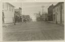
| Date: | |
|---|---|
| Description: | View down center of Rittenhouse Avenue with Lake Superior in the distance. The street is lined with businesses, sidewalks and lampposts. |
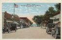
| Date: | |
|---|---|
| Description: | Colorized postcard view down a street (Rittenhouse Avenue) to Lake Superior. The street is lined with businesses and parked cars. Caption reads: "Street Sc... |
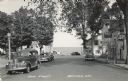
| Date: | 1950 |
|---|---|
| Description: | Photographic postcard view down Main Street, with Lake Superior in the distance. There is a cafe on the left and bars on the right. Cars are parked along t... |
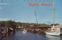
| Date: | |
|---|---|
| Description: | Photographic postcard view from water of a marina. Sailboats and motorboats are docked. More boats are stored up on the shoreline. Trees and buildings are ... |
If you didn't find the material you searched for, our Library Reference Staff can help.
Call our reference desk at 608-264-6535 or email us at: