 Filter: Categories of Wisconsin Historical Images
Filter: Subject of Superior, Lake
Filter: Subject of automobiles
Filter: Categories of Wisconsin Historical Images
Filter: Subject of Superior, Lake
Filter: Subject of automobiles
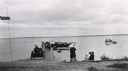
| Date: | 1910 |
|---|---|
| Description: | View towards shoreline of an automobile being driven on the Bayfield City Dock. Colonel Woods' boat, "Nebraska" is at the dock. Sam Fifields' "Stella" is a... |
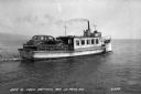
| Date: | 1938 |
|---|---|
| Description: | A car ferry transporting a car on Lake Superior between LaPointe, Madeline Island, and Bayfield. Two men are sitting on a bench near the car, and a shoreli... |
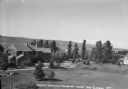
| Date: | 1938 |
|---|---|
| Description: | Large vacation homes in La Pointe, Madeline Island. Bayfield is in the background on the far shore of Lake Superior. |
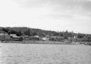
| Date: | 1942 |
|---|---|
| Description: | View from Lake Superior looking at the shoreline of Washburn. Houses, buildings, people, cars and trees are visible on shore. |

| Date: | 1923 |
|---|---|
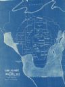
| Description: | This map shows trails, some in red, for automobiles. The right margin includes a key of markings as well as Minnesota and Wisconsin Highway signs. Communit... |

| Date: | 1936 |
|---|---|
| Description: | This pictorial tourist map from the Wisconsin Conservation Commission depicts vacation activities and identifies tourist destinations throughout the state.... |
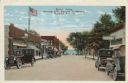
| Date: | |
|---|---|
| Description: | Colorized postcard view down a street (Rittenhouse Avenue) to Lake Superior. The street is lined with businesses and parked cars. Caption reads: "Street Sc... |
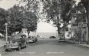
| Date: | 1950 |
|---|---|
| Description: | Photographic postcard view down Main Street, with Lake Superior in the distance. There is a cafe on the left and bars on the right. Cars are parked along t... |
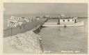
| Date: | 1949 |
|---|---|
| Description: | Photographic postcard view of the City Dock on Lake Superior. There are four boats, and people and cars are on the dock. A sign in the foreground reads: "N... |

| Date: | |
|---|---|
| Description: | Color postcard of view across water towards the "Nichevo II" ferry for Bayfield-Madeline Island moving through the water and filled with tourists and their... |
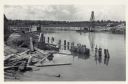
| Date: | 06 19 1958 |
|---|---|
| Description: | View over water towards storm damage in Cornucopia Harbor. West slip. There is a pile of wood along the shoreline in the foreground, with a boat moored jus... |
| Date: | 1928 |
|---|---|
| Description: | This blue line map shows the number of carload shipments to northern and central counties, with Mosinee being the central distribution point. Lake Michigan... |

| Date: | 1924 |
|---|---|
| Description: | This map shows railroads, electric lines, and steamship lines. The left margin includes an index of principal cities, and the lower left corner includes a... |

| Date: | 1920 |
|---|---|
| Description: | This map shows the entire state as well as portions of Iowa, Illinois, Minnesota, and Michigan. Counties outlined in yellow, cities, rivers, lakes, and rai... |

| Date: | 1920 |
|---|---|
| Description: | The map shows the entire state with cities, rivers, and lakes labeled. The upper and right margin include inset maps of Racine, Milwaukee, Waukesha, Applet... |

| Date: | 1928 |
|---|---|
| Description: | This map shows the entire state of Wisconsin as well as portions of Michigan, Minnesota, Iowa and Illinois. Lake Michigan, Lake Superior, Lake Winnebago a... |

| Date: | 1932 |
|---|---|
| Description: | This map shows automobile routes across Wisconsin and parts of Illinois, Michigan, Minnesota and Iowa. The Mississippi River, Lake Michigan, Lake Superior,... |

| Date: | 1933 |
|---|---|
| Description: | This road map shows automobile routes across Wisconsin as well as portions of Illinois, Minnesota, Iowa and Michigan. Lakes Michigan, Superior and Winnebag... |

| Date: | 1933 |
|---|---|
| Description: | This map contains automobile routes across Wisconsin and portions of Illinois, Iowa, Minnesota and Michigan as well. The state borders are clearly defined... |

| Date: | 1934 |
|---|---|
| Description: | This map provides automobile routes through Wisconsin along with portions of Illinois, Iowa, Minnesota and Michigan. Lake Superior, Lake Michigan, Green B... |
If you didn't find the material you searched for, our Library Reference Staff can help.
Call our reference desk at 608-264-6535 or email us at: