 Filter: Categories of Wisconsin Historical Images
Filter: Subject of Superior, Lake
Filter: County of Bayfield
Filter: Categories of Wisconsin Historical Images
Filter: Subject of Superior, Lake
Filter: County of Bayfield
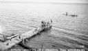
| Date: | 1935 |
|---|---|
| Description: | Boys and girls wearing bathing suits standing, swimming, or diving off of a large wooden dock into Chequamegon Bay, Lake Superior on the beach at Memorial ... |
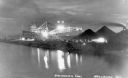
| Date: | 1936 |
|---|---|
| Description: | Unloading coal from a large ship in Lake Superior onto land near Washburn. There is a large conveyor that has lights glowing in the dark sky. A large pile ... |
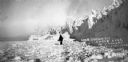
| Date: | 01 1930 |
|---|---|
| Description: | View of a man walking on the ice near the Lake Superior shoreline. |
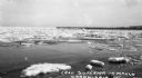
| Date: | 03 1935 |
|---|---|
| Description: | View taken from shore of ice chunks in Lake Superior near Cornucopia while the ice is melting. In the background along the shoreline is a long pier. |

| Date: | 1931 |
|---|---|
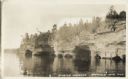
| Description: | View of the Squaw Bay Caves, near Cornucopia, with people in a boat off to the far left. The caves were renamed Mawikwe Bay, and Mawikwe is Ojibwe for weep... |
| Date: | 1885 |
|---|---|
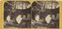
| Description: | Stereograph of a sailboat in Excursion Cave, on Hemlock Island of the Apostle Islands. A man can be seen sitting in the boat. |

| Date: | 1858 |
|---|---|
| Description: | Front cover of a guide book describing Bayfield and an account of a pleasure tour to Lake Superior. The title is surrounded by a decorative border with flo... |
| Date: | 1932 |
|---|---|
| Description: | Lake view of Apostle Islands sandstone caves along the shores of Lake Superior. |

| Date: | 1935 |
|---|---|
| Description: | House, cottages and property of Mrs. J.J. Fisher overlooking Lake Superior. |

| Date: | 1880 |
|---|---|
| Description: | This copy of an 1834 map in the American Fur Company's papers held by the New-York Historical Society shows an outline of Chequamegon Bay and Madeline Isla... |

| Date: | 1871 |
|---|---|
| Description: | Asaph Whittlesey arrived in Ashland in 1854, one of the earliest of the settlers who hoped the area would grow and make their fortunes. He drew this map of... |

| Date: | 1952 |
|---|---|
| Description: | This 1952 map of the northern parts of Bayfield and Douglas counties, Wisconsin, shows points established by E.T. Sweet in 1877, road points confirmed by S... |

| Date: | 1917 |
|---|---|
| Description: | This 1917 map of Bayfield County, Wisconsin, shows the township and range system, towns, sections, cities and villages, railroads, wagon roads, and lakes a... |

| Date: | 1935 |
|---|---|
| Description: | This pictorial map of northern Bayfield County, Wisconsin, shows the Chequamegon National Forest, the Red Cliff Indian Reservation, highways and roads, and... |

| Date: | 1871 |
|---|---|
| Description: | Asaph Whittlesey arrived in Ashland in 1854, one of the earliest of the settlers who hoped the area would grow and make their fortunes. He drew this map of... |

| Date: | 1906 |
|---|---|
| Description: | This 1906 map of Bayfield County, Wisconsin, shows towns, sections, cities, villages and post offices, land ownership, wagon roads, railroads, schools, gov... |

| Date: | 1967 |
|---|---|
| Description: | This tourist brochure for Bayfield County, Wisconsin, from 1967 includes a map of the county showing towns, cities and villages, highways and roads, railro... |
| Date: | |
|---|---|
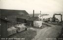
| Description: | Photographic postcard of an elevated view of the fishery and its dock. Caption reads: "View of Booth Fisheries Dock." |
| Date: | 1950 |
|---|---|
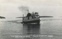
| Description: | Photographic postcard view of a fishing boat in Lake Superior with tourists on board. There is an island on the horizon. Caption reads: "'The Apostle Isla... |
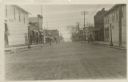
| Date: | |
|---|---|
| Description: | View down center of Rittenhouse Avenue with Lake Superior in the distance. The street is lined with businesses, sidewalks and lampposts. |
If you didn't find the material you searched for, our Library Reference Staff can help.
Call our reference desk at 608-264-6535 or email us at: