 Filter: Categories of Wisconsin Historical Images
Filter: Subject of Streets
Filter: Year of 1800-1899
Filter: Year of 1870-1879
Filter: Categories of Wisconsin Historical Images
Filter: Subject of Streets
Filter: Year of 1800-1899
Filter: Year of 1870-1879

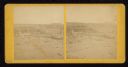
| Date: | 09 1871 |
|---|---|
| Description: | Bird's-eye view of Peshtigo, before it was destroyed by fire on the night of October 8, 1871. |

| Date: | 1870 |
|---|---|
| Description: | This bird's-eye-view map shows roads, a river with boats, and homes. The bottom margin of the map includes an index. |
| Date: | 1871 |
|---|---|
| Description: | Street scene showing destruction after Peshtigo fire. |
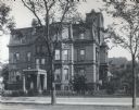
| Date: | 1879 |
|---|---|
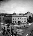
| Description: | The facade of the McCormick family residence at 675 Rush Street, which takes up an entire block between Erie and Huron Streets. Cyrus Hall McCormick, Sr. h... |
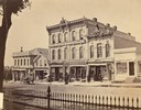
| Date: | 1873 |
|---|---|
| Description: | Ellsworth Block on North Pinckney Street between East Washington and East Mifflin Streets as seen from the Capitol Park. Storefronts include the Dry Goods ... |
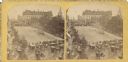
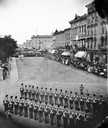
| Date: | 07 04 1876 |
|---|---|
| Description: | Stereograph of view of procession, military company and citizens at Great Centennial Day at the Capitol Square. Scene at Main and Carroll Streets showing t... |
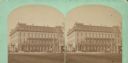
| Date: | 1871 |
|---|---|
| Description: | Exterior view of the Park Hotel. Among its fine features are black walnut trim, Brussels carpet, marble-topped furniture, and spring beds. The hotel was on... |

| Date: | 1873 |
|---|---|
| Description: | Bird's-eye map of La Crosse from the Mississippi River. |
| Date: | 06 1877 |
|---|---|
| Description: | The Guppey Guard, a Wisconsin state militia unit, in formation on a street in Portage. |
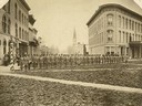
| Date: | 07 1876 |
|---|---|
| Description: | Elevated view from the Park Hotel looking east to the corner of Carroll and Main Streets in Madison. Soldiers are in formation as a part of the centennial ... |
| Date: | 1873 |
|---|---|
| Description: | Locomotive, with view east on West Washington Avenue toward the Wisconsin State Capitol. There is a sign near the tracks that reads: "Look Out for The Cars... |
| Date: | 1873 |
|---|---|
| Description: | Elevated view of employees, along with young children, posed around a wagon loaded with barrels of beer in front of Hausmann's Capital Brewery at the corne... |

| Date: | 1872 |
|---|---|
| Description: | Bird's-eye map of Milwaukee on Lake Michigan. |

| Date: | 1878 |
|---|---|
| Description: | Bird's-eye map of Chilton with insets of points of interest, including P.H. Becker's Brewery, Chilton House, and Gutheil's Block. |

| Date: | 1874 |
|---|---|
| Description: | Bird's-eye map of Chippewa Falls. |

| Date: | 1877 |
|---|---|
| Description: | Bird's-eye map of Janesville on the Rock River. |

| Date: | 1875 |
|---|---|
| Description: | Bird's-eye map after a fire destroyed a large area of the town. In memory of the Great Conflagration on April 28th, 1875. Taken from the North-Side. |
If you didn't find the material you searched for, our Library Reference Staff can help.
Call our reference desk at 608-264-6535 or email us at:


