 Filter: Categories of Wisconsin Historical Images
Filter: Subject of Streets
Filter: Year of 1800-1899
Filter: Creator Name of Unknown
Filter: Categories of Wisconsin Historical Images
Filter: Subject of Streets
Filter: Year of 1800-1899
Filter: Creator Name of Unknown
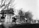
| Date: | 1890 |
|---|---|
| Description: | Several houses at the intersection of Wilson Street and Monona Avenue with the home of Simeon Mills, one of Madison's most prominent citizens, on the corne... |
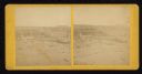
| Date: | 1871 |
|---|---|
| Description: | Street scene showing destruction after Peshtigo fire. |

| Date: | 1884 |
|---|---|
| Description: | A sign for Fauerbach's Brewery depicting a young woman and the brewery. |
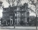
| Date: | 1879 |
|---|---|
| Description: | The facade of the McCormick family residence at 675 Rush Street, which takes up an entire block between Erie and Huron Streets. Cyrus Hall McCormick, Sr. h... |
| Date: | 1860 |
|---|---|
| Description: | Elevated view of Barstow Street looking north. View from the corner of Main Street, where the Eau Claire Book and Stationary Company later stood, looking n... |
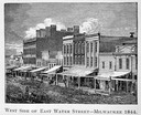
| Date: | 1844 |
|---|---|
| Description: | Illustration of the west side of East Water Street. |
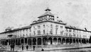
| Date: | 1888 |
|---|---|
| Description: | View of the Chequamegon Hotel, built by the Wisconsin Central railroad interests and opened in 1877. It faced the bay and had a long series of steps leadin... |
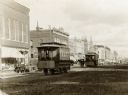
| Date: | 1886 |
|---|---|
| Description: | First electric street railway service in Wisconsin. |
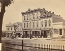
| Date: | 1873 |
|---|---|
| Description: | Ellsworth Block on North Pinckney Street between East Washington and East Mifflin Streets as seen from the Capitol Park. Storefronts include the Dry Goods ... |

| Date: | 1897 |
|---|---|
| Description: | A view from the capitol looking west up State Street toward the University of Wisconsin-Madison with the Holy Redeemer Church, Holy Redeemer School, Red Gy... |
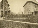
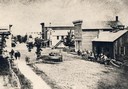
| Date: | 06 1877 |
|---|---|
| Description: | The Guppey Guard, a Wisconsin state militia unit, in formation on a street in Portage. |
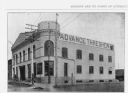
| Date: | 1899 |
|---|---|
| Description: | Exterior view of the Advance Thresher Company, 601 Williamson Street, as seen in "Madison, Wis. And It's Points Of Interest." The dealer was one of many wh... |

| Date: | 1836 |
|---|---|
| Description: | The top map is the "Plat of Madison the Capitol of Wisconsin." The bottom map is the "Map of the Four Lake Country. Taken from the Township Maps in the U.S... |

| Date: | 1889 |
|---|---|
| Description: | Illustration of the exterior of the Fuller Opera House, which is a detail from a bird's-eye view map of Madison. |

| Date: | 1874 |
|---|---|
| Description: | Bird's-eye map of Chippewa Falls. |

| Date: | 1881 |
|---|---|
| Description: | Bird's-eye map of Milton Junction. |

| Date: | 1879 |
|---|---|
| Description: | This map is a bird's-eye view of Wausau, the County Seat of Marathon County. The map features an index of points of interest. |

| Date: | 1860 |
|---|---|
| Description: | Bird's-eye drawing of New Glarus. |
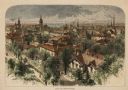
| Date: | 1874 |
|---|---|
| Description: | Bird's-eye view of Milwaukee looking southwest toward the county courthouse under construction in the public square west of St. John's Cathedral. |
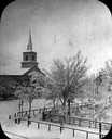
| Date: | 1860 |
|---|---|
| Description: | Elevated wintertime view of the intersection of South Carroll and West Main Streets, showing the First Baptist Church constructed in 1854, the wooden fence... |
If you didn't find the material you searched for, our Library Reference Staff can help.
Call our reference desk at 608-264-6535 or email us at: