 Filter: Categories of Wisconsin Historical Images
Filter: Subject of Streets
Filter: Community of Prairie du Chien
Filter: Categories of Wisconsin Historical Images
Filter: Subject of Streets
Filter: Community of Prairie du Chien
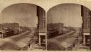
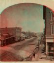
| Date: | 1880 |
|---|---|
| Description: | Stereograph looking northeast from Case's Block. |
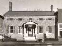
| Date: | 1959 |
|---|---|
| Description: | Woman's Building, one of the oldest buildings in the city. It is believed to have been built in 1842 by John Folsom, an early settler and farmer on the hei... |
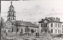
| Date: | 1887 |
|---|---|
| Description: | St. Gabriel's Roman Catholic Church. Horse-drawn vehicles and pedestrians are on the street and sidewalk in front of the church. |
| Date: | 1925 |
|---|---|
| Description: | This building was supposedly once used as a storage house for the Northwest Fur Co. |
| Date: | 1900 |
|---|---|
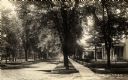
| Description: | View of Minnesota Street, with a view down the right sidewalk with houses and trees. |
| Date: | 1910 |
|---|---|
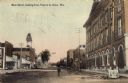
| Description: | Caption reads: "Main Street, looking East. Prairie du Chien, Wis." View down street with a large building on the right. |
| Date: | 1865 |
|---|---|
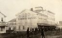
| Description: | Kane's Hotel, built in about 1839 by Ezekiel Tainter, and then called the Phoenix Hotel, on Main Street. It passed through many hands but retained the orig... |

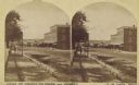
| Date: | 1890 |
|---|---|
| Description: | Elevated view across street towards the Dousman Office building, later used as a pearl button factory. A large group of people are sitting and standing at ... |

| Date: | 1906 |
|---|---|
| Description: | Crawford County Courthouse, built in 1875. |
| Date: | 1880 |
|---|---|
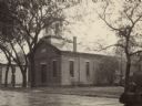
| Description: | Congregational church, organized in 1852. |

| Date: | 1880 |
|---|---|
| Description: | Exterior view of the Commercial Hotel. Horse-drawn vehicles are in front of the building. People are standing on the sidewalk in front. |

| Date: | 1906 |
|---|---|
| Description: | Bluff Street looking east. Pedestrians are on the sidewalks. |

| Date: | 1906 |
|---|---|
| Description: | Bluff Street looking east. A sign painted on a building on the left reads: "Owl Cigar Now 5 CTS". |

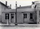
| Date: | 1900 |
|---|---|
| Description: | Bluff Street looking east. Pencil notation on this photograph reads: "House marked X is my home and is said to be built from stone from Fort Crawford. -A.C... |

| Date: | 1900 |
|---|---|
| Description: | Bluff street looking west. Posters are on a wall on the far right next to a building with an awning that reads: "Saloon". |
| Date: | 1880 |
|---|---|
| Description: | Stereograph looking northeast from Case's Block. |
| Date: | 1875 |
|---|---|
| Description: | Stereograph view of Black Hawk Avenue. |

| Date: | 1882 |
|---|---|
| Description: | This map is ink on cardboard and shows the location of military forts over the course of years. Also shown are points of interest, streets, the Mississippi... |

| Date: | 1864 |
|---|---|
| Description: | This map is ink, pencil, and color on paper and shows numbered lots and labeled streets. The bottom margin of the map reads: "Recorded in the Registry of d... |

| Date: | 1976 |
|---|---|
| Description: | This map includes an index of streets, government and historic buildings, hospitals, schools, places of recreation, churches, cemeteries, and other miscell... |
If you didn't find the material you searched for, our Library Reference Staff can help.
Call our reference desk at 608-264-6535 or email us at: