 Filter: Categories of Wisconsin Historical Images
Filter: Subject of Streets
Filter: Community of Milwaukee
Filter: Year of 1800-1899
Filter: Creator Name of Unknown
Filter: Categories of Wisconsin Historical Images
Filter: Subject of Streets
Filter: Community of Milwaukee
Filter: Year of 1800-1899
Filter: Creator Name of Unknown
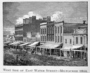
| Date: | 1844 |
|---|---|
| Description: | Illustration of the west side of East Water Street. |
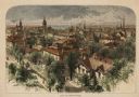
| Date: | 1874 |
|---|---|
| Description: | Bird's-eye view of Milwaukee looking southwest toward the county courthouse under construction in the public square west of St. John's Cathedral. |
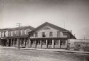
| Date: | 1870 |
|---|---|
| Description: | Dousman Warehouse, East Water Street. Originally located on the wharf parallel with the river. Built and used by George and Talbot, brothers of Hercules Do... |
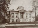
| Date: | 1895 |
|---|---|
| Description: | Home of John Johnston (1836-1904), a successful Milwaukee banker, at 645 Franklin Place, also know as "The Lion House." Home is set back from the road, wit... |
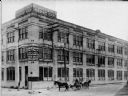
| Date: | 1899 |
|---|---|
| Description: | Exterior view of the building at the corner of N. 12th St. and W. St. Paul Avenue that housed Badger State Shoe Co. and Saveland Manufacturing Co. Two hors... |

| Date: | 1857 |
|---|---|
| Description: | Caption reads: "THE LOTS embraced in the proposed Addition, are situated in the Fourth Ward of the City of Milwaukee, about twenty minutes walk from Spring... |

| Date: | 1858 |
|---|---|
| Description: | Map of Martineau's Addition in the first ward of Milwaukee as well as buildings and location of adjacent additions with landowners names. |

| Date: | 1840 |
|---|---|
| Description: | Pen-and-ink on paper. Map shows 1840’s homes with owner names, a Native American cemetery, and other points of interest. Relief shown by hachures. Oriented... |

| Date: | 1800 |
|---|---|
| Description: | Ink on tracing cloth. Shows property owners in block 69, between Fourth and Third Street. |

| Date: | 1800 |
|---|---|
| Description: | Map of additions to Milwaukee. Several of the additions are outlined in colors and many streets, waterways, and some landmarks are labelled. |

| Date: | 1896 |
|---|---|
| Description: | Snapshot of a young man with two young women chatting on Wisconsin Street. The scene is near the Grand Avenue bridge which appears in the background. |

| Date: | 1892 |
|---|---|
| Description: | This map shows water pipes, hydrants, stop cocks, check valves, fire cysterns, and manholes. Also shown are block numbers, streets, railroads, parks, cemet... |

| Date: | 1893 |
|---|---|
| Description: | This map covers west to Wauwatosa, north to North Milwaukee, and south to South Milwaukee and shows street railways, city limits, parks, roads, railroads, ... |

| Date: | 1899 |
|---|---|
| Description: | This map shows parks, block numbers, Lake Michigan, and railroads. Relief is shown by contours. Also included is an explanation that lists how many miles o... |

| Date: | 1890 |
|---|---|
| Description: | Five teenagers ride "High Wheeler or Penny-Farthing" bicycles down the street. Grand Avenue Congregational Church is in the background. Mature trees are on... |

| Date: | 1894 |
|---|---|
| Description: | This map shows sewers, intercepting sewers, manholes, block numbers, streets, railroads, parks, cemeteries, and Lake Michigan. The right margin reads: "Tot... |

| Date: | 1879 |
|---|---|
| Description: | This map shows asylums, cemeteries, hospitals, parks, streets, and wards. Relief is shown by contours. Also included are manuscript annotations in pencil. ... |
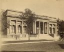
| Date: | 1888 |
|---|---|
| Description: | View across street towards the facade of the original Layton Art Gallery building at 758 N. Jefferson Street. Two men stand at the top of the stairs betwee... |

| Date: | 1895 |
|---|---|
| Description: | View from street towards a streetcar passing in front of the 1872 Brumder building located, according to a note of the reverse of the photograph, "on N. E.... |
If you didn't find the material you searched for, our Library Reference Staff can help.
Call our reference desk at 608-264-6535 or email us at: