 Filter: Categories of Wisconsin Historical Images
Filter: Subject of Streams
Filter: County of Dane
Filter: Year of 1900-1999
Filter: Categories of Wisconsin Historical Images
Filter: Subject of Streams
Filter: County of Dane
Filter: Year of 1900-1999
| Date: | 01 14 1949 |
|---|---|
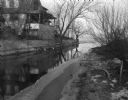
| Description: | Murphy's Creek (now Wingra Creek) entrance to Lake Monona, the site where 2-year-old's Toni Dussling and Haskell Furumos drowned. |
| Date: | 1910 |
|---|---|
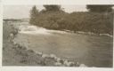
| Description: | The mill race as it flows from Lake Mendota into Tenney Park. |

| Date: | 1904 |
|---|---|
| Description: | This 1904 map of Dane County, Wisconsin, shows postal routes, post office locations, towns, sections, cities and villages, roads, railroads, collection box... |

| Date: | 1924 |
|---|---|
| Description: | This map of the Four Lakes region shows points of interest around the lakes, state trunk highways and other roads, railroads, and lakes and streams. Manusc... |

| Date: | 1925 |
|---|---|
| Description: | This 1925 map of Dane County, Wisconsin, issued by the Madison Association of Commerce shows the township and range grid, towns, sections, cities and villa... |

| Date: | 1942 |
|---|---|
| Description: | This 1942 map of the Town of Middleton, Dane County, Wisconsin, shows sections, landowners, highways and roads, a railroad, the village of Middleton, and l... |
| Date: | 1930 |
|---|---|
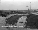
| Description: | View from driveway over a stream towards a row of six log cabins to the left Highway 51. A Texaco Station and a delivery truck are on the far left. Cars ar... |

| Date: | 07 18 1955 |
|---|---|
| Description: | Five teen boys stand ankle deep in Black Earth Creek (west of Cross Plains) while working together to build a conversion dam in the creek bed. The boys are... |

| Date: | 07 18 1955 |
|---|---|
| Description: | Two teen boys and an adult stand in ankle deep Black Earth Creek (west of Cross Plains) while working together to build a "V" shaped conversion dam, pointi... |

| Date: | 07 18 1955 |
|---|---|
| Description: | Three teen boys work together to build up the side of the creek to stop the flowing water from washing the soil away on an edge of Black Earth Creek west o... |

| Date: | 1923 |
|---|---|
| Description: | Map showing the parcel of land on the shore of Lake Monona acquired by the City of Madison for a park (today known as Olbrich Park). |
| Date: | 10 20 1963 |
|---|---|
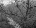
| Description: | Small stream through willow tree. In the background are tree-covered hills. |
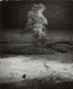
| Date: | 06 25 1964 |
|---|---|
| Description: | Single tree in the valley meadow below Stewart park. A small loop of a stream is to the right of the tree. A wooded hill is in the background. |

| Date: | 03 1965 |
|---|---|
| Description: | Keith Brigham is shown checking the U.S. Geological Survey stream gauging station located at the Yahara river locks on Lake Waubesa near McFarland. |
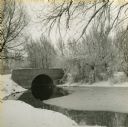
| Date: | 1940 |
|---|---|
| Description: | View from snowy shoreline towards a bridge over Wingra Creek, between Lake Wingra and Lake Monona, in Vilas Park. The road over the bridge leads into the U... |
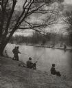
| Date: | 1935 |
|---|---|
| Description: | Elevated view of a man standing on a bank on the right, and two boys standing on a log on the left, are fishing in the mill stream below an old mill. Two b... |

| Date: | 1949 |
|---|---|
| Description: | Black Earth Creek in the winter, with the banks covered with snow. Large trees are leaning over the creek on the right bank. In the background are a fence,... |
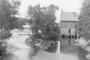
| Date: | 1951 |
|---|---|
| Description: | First fishing near Vilas Park on Murphy's Creek (now known as Wingra Creek.) Many people are set up to fish on both sides of the tree-lined banks. |

| Date: | 11 1958 |
|---|---|
| Description: | Black Earth Creek with November Snow. The water meanders and a large tree grows on the bank. |

| Date: | 01 1963 |
|---|---|
| Description: | Dried grass is caught in a barb wire fence that is leaning over near a small creek. Snow is on the ground. |
If you didn't find the material you searched for, our Library Reference Staff can help.
Call our reference desk at 608-264-6535 or email us at: