Filter: Categories of Wisconsin Historical Images
Filter: Subject of Streams
Filter: County of Dane
Filter: Subject of land
Filter: Categories of Wisconsin Historical Images
Filter: Subject of Streams
Filter: County of Dane
Filter: Subject of land

| Date: | 1876 |
|---|---|
| Description: | View of a farmstead with fences, haystacks and a wooden outbuilding. Two men are posing on top of McCord Rock, one of them saluting with his hat. Another ... |

| Date: | 1874 |
|---|---|
| Description: | Elevated view from hill of Clinton, now Rockdale. Three men are in the middle distance, looking east across Koshonong Creek towards a mill dam, bridge and ... |

| Date: | |
|---|---|
| Description: | Letterhead of Madison Mobile Homes, with a three-quarter view of a mobile home parked in a clearing near a wooded area on a shoreline, with the slogan "Liv... |

| Date: | 1835 |
|---|---|
| Description: | These maps of the towns of Westport, Madison, and Blooming Grove, Dane County, Wisconsin, show sections, roads, trails, lakes and streams, and wetlands fro... |

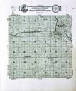
| Date: | 1925 |
|---|---|
| Description: | This 1925 map of Dane County, Wisconsin, issued by the Madison Association of Commerce shows the township and range grid, towns, sections, cities and villa... |

| Date: | 1890 |
|---|---|
| Description: | This late-19th century map of Dane County, Wisconsin, shows the township and range grid, towns, sections, cities and villages, lakes and streams, roads, an... |

| Date: | 1867 |
|---|---|
| Description: | This 1867 manuscript map by Increase Lapham shows the topography and geology of the Blue Mounds region in the Town of Brigham in Iowa County and the towns ... |

| Date: | 1873 |
|---|---|
| Description: | A map of the township of Primrose from the "Atlas of Dane County." |

| Date: | 1873 |
|---|---|
| Description: | A map of the township of Montrose from the "Atlas of Dane County." |

| Date: | 07 18 1955 |
|---|---|
| Description: | Five teen boys stand ankle deep in Black Earth Creek (west of Cross Plains) while working together to build a conversion dam in the creek bed. The boys are... |

| Date: | 07 18 1955 |
|---|---|
| Description: | Two teen boys and an adult stand in ankle deep Black Earth Creek (west of Cross Plains) while working together to build a "V" shaped conversion dam, pointi... |

| Date: | 07 18 1955 |
|---|---|
| Description: | Three teen boys work together to build up the side of the creek to stop the flowing water from washing the soil away on an edge of Black Earth Creek west o... |
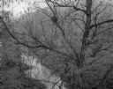
| Date: | 10 20 1963 |
|---|---|
| Description: | Small stream through willow tree. In the background are tree-covered hills. |
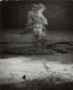
| Date: | 06 25 1964 |
|---|---|
| Description: | Single tree in the valley meadow below Stewart park. A small loop of a stream is to the right of the tree. A wooded hill is in the background. |
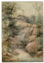
| Date: | |
|---|---|
| Description: | Watercolor painting of a cascade of water over boulders in a stream. Trees and foliage are growing on both sides. The scene may be Madison Creek, west of... |

| Date: | 1949 |
|---|---|
| Description: | Black Earth Creek in the winter, with the banks covered with snow. Large trees are leaning over the creek on the right bank. In the background are a fence,... |

| Date: | 11 1958 |
|---|---|
| Description: | Black Earth Creek with November Snow. The water meanders and a large tree grows on the bank. |
If you didn't find the material you searched for, our Library Reference Staff can help.
Call our reference desk at 608-264-6535 or email us at: