 Filter: Categories of Wisconsin Historical Images
Filter: Subject of Slavery
Filter: Subject of maps
Filter: Categories of Wisconsin Historical Images
Filter: Subject of Slavery
Filter: Subject of maps
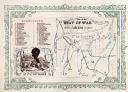
| Date: | 1860 |
|---|---|
| Description: | African American man, left, map depicting Maryland, Virginia, Delaware and the border of Pennsylvania, right. Key of "DIRECTIONS" in upper right corner. At... |
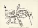
| Date: | |
|---|---|
| Description: | A hand-drawn map of a house labeled in both English and Chinese. Notes include escape routes. Two girls were kept here. |

| Date: | 1770 |
|---|---|
| Description: | The south west sheet of a four sheet map of Virginia, showing the counties, mountains, rivers, court houses, a few cities, and mills. A few Plantations ar... |

| Date: | 1780 |
|---|---|
| Description: | This map shows the townships, parishes, cities, towns, plantations, lakes, rivers, swamps, and roads near the coast of South Carolina and Georgia. Emphasis... |

| Date: | 1865 |
|---|---|
| Description: | Portrait of Reverend Edward Mathews standing in front of a "Moral Map of the United States." He is holding a long, wooden pointer and is gesturing towards ... |
If you didn't find the material you searched for, our Library Reference Staff can help.
Call our reference desk at 608-264-6535 or email us at: