 Filter: Categories of Wisconsin Historical Images
Filter: Subject of Ships
Filter: Subject of social issues
Filter: Categories of Wisconsin Historical Images
Filter: Subject of Ships
Filter: Subject of social issues
| Date: | |
|---|---|
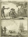
| Description: | Two illustrations depicting the capture by Europeans of Africans who were taken away on ships to be slaves. The caption is in French. |

| Date: | 06 1942 |
|---|---|
| Description: | A member of the United Fruit Company's S.S. Santa Marta relaxing in his bunk while reading a book in Spanish and smoking a cigarette. The man is on ... |

| Date: | 1945 |
|---|---|
| Description: | Second Lieutenant Louis Connick smiling for a photograph aboard USS Samaritan, a hospital ship. He is lying in a bed and holding a cigarette. He is ... |

| Date: | 09 18 1908 |
|---|---|
| Description: | Luncheon menu from the S.S. Marquette, with a framed illustration of a white-bearded man in profile holding a pipe and turning away to look at a sai... |
| Date: | 1918 |
|---|---|
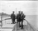
| Description: | Major McArdle with two British officers in uniform on board the launch "Wisconsin." All three men are smoking cigarettes. Another ship and a shoreline can ... |
| Date: | 01 22 1939 |
|---|---|
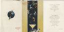
| Description: | Exterior and page from the interior of the menu for the farewell dinner aboard the R.M.S. Volendam, with party streamers and dinner guests in formal... |

| Date: | 05 04 1948 |
|---|---|
| Description: | Assembly Dinner menu from the Holland-America Line R.M.S. Nieuw Amsterdam, with revelers in dress suits and party frocks walking and holding drinks ... |
| Date: | 1891 |
|---|---|
| Description: | Frederick Layton standing on deck smoking a cigar while at sea in a Kodak #2 camera portrait by T.W. Ingersoll from St. Paul, Minnesota. The photographer's... |

| Date: | 1783 |
|---|---|
| Description: | This map is hand-colored and shows the boundaries of British, Spanish, and the newly recognized American claims, as well as the fishing rights granted to F... |

| Date: | 1755 |
|---|---|
| Description: | Map of Virginia and parts of Maryland, North Carolina, and New Jersey. It shows borders, boundary lines, some Native American land, counties, cities, towns... |
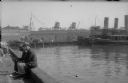
| Date: | 1935 |
|---|---|
| Description: | The funnels (smokestacks) of two large steamships are visible over warehouse buildings on a pier of a southern American port. Both ships have nautical flag... |
If you didn't find the material you searched for, our Library Reference Staff can help.
Call our reference desk at 608-264-6535 or email us at: