 Filter: Categories of Wisconsin Historical Images
Filter: Subject of Ships
Filter: Subject of international relations
Filter: Categories of Wisconsin Historical Images
Filter: Subject of Ships
Filter: Subject of international relations

| Date: | 1655 |
|---|---|
| Description: | Christopher Columbus begins his first expedition, 1492. |

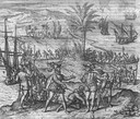
| Date: | 1655 |
|---|---|
| Description: | Encounter with Indians during Christopher Columbus' first expedition in 1492. |
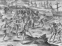
| Date: | 1655 |
|---|---|
| Description: | Scene on Hispaniola in 1500, when Columbus was forced to return to Spain after a new adminstrator had arrived. |
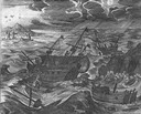
| Date: | 1655 |
|---|---|
| Description: | Scene from Drake Expedition near Rio de la Plata, Brazil, ca. 1578. |
| Date: | 1655 |
|---|---|
| Description: | Scene from near Jamestown Settlement in Virginia, 1615. |
| Date: | 1917 |
|---|---|
| Description: | Members of the Root Commission trip to Russia playing "ship golf" on board the Buffalo. Original caption identifies the participants as: "Cyrus McCo... |
| Date: | 1917 |
|---|---|
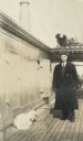
| Description: | Man identified in original caption as "Mr. Duncan" on board the ship Buffalo as part of the Root Commission's trip to Russia. A goat appears to be l... |
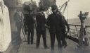
| Date: | 1917 |
|---|---|
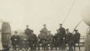
| Description: | Root Commission members seated aboard the deck of the Buffalo. |

| Date: | 1783 |
|---|---|
| Description: | This map is hand-colored and shows the boundaries of British, Spanish, and the newly recognized American claims, as well as the fishing rights granted to F... |

| Date: | 1733 |
|---|---|
| Description: | This map of North America shows settlements, rivers, lakes, Native American land, trade winds, and numerous topographical features such as forests and moun... |

| Date: | 1758 |
|---|---|
| Description: | Map showing lakes, rivers, cities, Native American land, and the boundaries of French and English claims in America and Canada north of New York. A title c... |

| Date: | 1770 |
|---|---|
| Description: | Map of North America from the Great Lakes to the northern portion of South America. It shows cities, Native American land, mountains, swamps, lakes, rivers... |
If you didn't find the material you searched for, our Library Reference Staff can help.
Call our reference desk at 608-264-6535 or email us at: