 Filter: Categories of Wisconsin Historical Images
Filter: Subject of Ships
Filter: Subject of coasts
Filter: Categories of Wisconsin Historical Images
Filter: Subject of Ships
Filter: Subject of coasts
| Date: | |
|---|---|
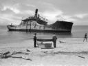
| Description: | View from shoreline toward the wreck of the S.S. Atlantus, a concrete hulled ship in the water near a shoreline. In the foreground are three men on ... |
| Date: | |
|---|---|
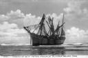
| Description: | A bark, the "Galena," stranded on Clatsop Beach, with three men and two women on the beach in the foreground. |
| Date: | |
|---|---|
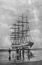
| Description: | A view of the wrecked ship beached in shallow water. The ship ran ashore in 1906. Caption reads: "Wreck of Ship 'Peter Iredale' Clatsop Beach, Ore." |
| Date: | |
|---|---|
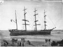
| Description: | Elevated view across beach toward the ship beached in shallow water. There is a crowd of people on the beach in the foreground. Caption reads: "Ship 'Galen... |
| Date: | |
|---|---|
| Description: | View of a stained glass window erected in 1920 in honor of the women of Plymouth Plantation. On the center panel, a ship is in the bay while a man and wom... |
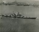
| Date: | 10 23 1945 |
|---|---|
| Description: | Aerial view of U.S.S. Wisconsin (BB-64) in San Francisco Bay. Several boats can be seen in the water near the ship and San Francisco is visible in t... |

| Date: | 1918 |
|---|---|
| Description: | Map showing Aleppo, Zor, Syria, Lebanon, Beirut, Jerusalem, with an inset map of the Sinai Peninsula and Egyptian frontier. Also shows the locations of rai... |

| Date: | |
|---|---|
| Description: | Letterhead of Johnson & Melaas, merchant tailors and cloth dealers, "Buyers of wool and Wisconsin leaf tobacco," with an engraving of a waterfront view of ... |

| Date: | 1700 |
|---|---|
| Description: | Map of the western hemisphere showing settelments, coastal features, islands, rivers, lakes, and pictoral representations of forests and mountains. The Gre... |

| Date: | 1755 |
|---|---|
| Description: | Map of the northeastern portion of America and Canada, east of the Hudson River and south from Labrador. It names regions, colonies, cities, numerous forts... |

| Date: | 1759 |
|---|---|
| Description: | Map of north eastern Canada and parts of New England, showing settlements, cities, portages, Native American land, mountains, lakes, and rivers. The unusua... |

| Date: | 1795 |
|---|---|
| Description: | Map of Connecticut showing counties, townships, cities, roads, islands, swamps, hills, mountains, lakes, rivers, reefs, and numerous other geographical and... |

| Date: | 10 1776 |
|---|---|
| Description: | Broadside map showing the British invasion of New York city in August and September of 1776. The map shows important cities, forts, roads, hills, mountains... |

| Date: | 02 1777 |
|---|---|
| Description: | Map depicting the campaigns of October and November 1776, in Manhattan, Westchester, and part of New Jersey, published only a few months after the conclusi... |

| Date: | 1781 |
|---|---|
| Description: | Map of the Southeastern part of the British Colonies in North America, Gulf Coast and Caribbean. It illustrates the of the Spanish and English fleets, part... |
If you didn't find the material you searched for, our Library Reference Staff can help.
Call our reference desk at 608-264-6535 or email us at: