 Filter: Categories of Wisconsin Historical Images
Filter: Subject of Science
Filter: Subject of transportation
Filter: Year of 1800-1899
Filter: Categories of Wisconsin Historical Images
Filter: Subject of Science
Filter: Subject of transportation
Filter: Year of 1800-1899

| Date: | 1823 |
|---|---|
| Description: | In 1823 U.S. Army major Stephen H. Long led an expedition of scientific, trade, and military investigation up the Mississippi River and the Red River of th... |
| Date: | 1867 |
|---|---|
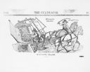
| Description: | A diagram of McCormick's cultivator-reaper, which was patented in 1845. The illustration, titled "The Cultivator" depicts a man using a rake to remove the ... |
| Date: | 05 1866 |
|---|---|
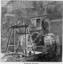
| Description: | Engraved view of two men in a train locomotive observing the weighing of pig lead. Several bars of lead are stacked near the scale. |

| Date: | 1893 |
|---|---|
| Description: | Front and back covers of an advertising brochure for the New Empire line of mowers, reapers and grain binders manufactured by J.F. Seiberling & Company. Th... |
| Date: | 1896 |
|---|---|
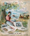
| Description: | Front cover of an advertising catalog for Aultman, Miller and Company, manufacturers of agricultural equipment. Features a chromolithograph of a woman sit... |

| Date: | 1855 |
|---|---|
| Description: | Map reads "Our Country" which is accompanied by a sailor with a flag to the left and workers rejoicing under the Constitution and Laws to the right. Across... |
| Date: | 1880 |
|---|---|
| Description: | View down Langdon Street of building at base of Bascom Hill at the intersection with Park Street. This building stood from 1876-1884. A horse and carriage ... |

| Date: | 1890 |
|---|---|
| Description: | View towards southwest of exterior of building on the University of Wisconsin-Madison campus. Music Hall can be seen on the left on the opposite side of Ba... |
| Date: | 1890 |
|---|---|
| Description: | Elevated view across Park Street of Science Hall. University of Wisconsin-Madison campus. Part of the Chemical Laboratory building is on the right, and Mus... |
| Date: | 1884 |
|---|---|
| Description: | View across Park Street of Science Hall building after the fire of December 1, 1884, on the University of Wisconsin-Madison campus. The building's exterior... |

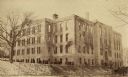
| Date: | 1887 |
|---|---|
| Description: | View across Park Street towards the northwest of the new Science Hall, shortly after its completion on the University of Wisconsin-Madison campus. Part of ... |
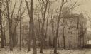
| Date: | 1884 |
|---|---|
| Description: | View from Bascom Hill towards the west facade of the original Science Hall building (1876-1884) on the University of Wisconsin-Madison campus after the fir... |

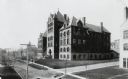
| Date: | 1887 |
|---|---|
| Description: | Exterior of Science Hall on the University of Wisconsin-Madison campus. View from across Park Street taken shortly after completion of new building after f... |
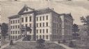
| Date: | 1876 |
|---|---|
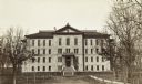
| Description: | Engraving of the first Science Hall at University of Wisconsin-Madison. |
| Date: | 1897 |
|---|---|
| Description: | View through trees and lawn towards the northwest across Park Street of Science Hall on the University of Wisconsin-Madison campus. |

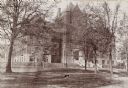
| Date: | 1895 |
|---|---|
| Description: | University of Wisconsin-Madison Science Hall. View looking up Langdon Street, with a horse-drawn wagon on the right. |

| Date: | 1887 |
|---|---|
| Description: | Elevated view over roof tops of lower campus looking up towards Bascom Hall. Science Hall at the end of Langdon Street is on the right side of Bascom Hill ... |

| Date: | 1894 |
|---|---|
| Description: | Elevated view across open space with an oval track, looking towards Science Hall at the end of Langdon Street on the University of Wisconsin-Madison campus... |

| Date: | 1866 |
|---|---|
| Description: | This thematic shows the effects that Lake Michigan has had on Wisconsin mean temperatures in January and July. The map shows counties, some cities, rivers ... |

| Date: | 1865 |
|---|---|
| Description: | Drawn the last year of the Civil War, this thematic map shows the effects that Lake Michigan has had on Wisconsin temperatures in January and July. The map... |
If you didn't find the material you searched for, our Library Reference Staff can help.
Call our reference desk at 608-264-6535 or email us at: