 Filter: Categories of Wisconsin Historical Images
Filter: Subject of Science
Filter: Subject of persons
Filter: Subject of great lakes
Filter: Categories of Wisconsin Historical Images
Filter: Subject of Science
Filter: Subject of persons
Filter: Subject of great lakes

| Date: | 1855 |
|---|---|
| Description: | Map reads "Our Country" which is accompanied by a sailor with a flag to the left and workers rejoicing under the Constitution and Laws to the right. Across... |
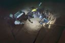
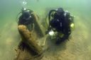
| Date: | 08 05 2013 |
|---|---|
| Description: | Underwater view of two archeologists surveying a portion of the Lakeland. The divers are using cameras, with three or four strobes attached by an ar... |
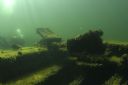
| Date: | 06 22 2015 |
|---|---|
| Description: | Underwater starboard view of the Lakeland. While the ship remains largely intact, it is split in half, with the back end of the ship in the backgrou... |
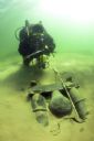
| Date: | 06 10 2005 |
|---|---|
| Description: | Underwater view of algae and mussels living on the engine mount of the sunken Louisiana. To the left, an underwater archeologist is surveying the si... |

| Date: | 06 10 2005 |
|---|---|
| Description: | Underwater view of an underwater archeologist investigating the drift pins of the Louisiana. Algae and mussels are covering most of the wood of the ... |

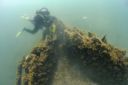
| Date: | 08 03 2014 |
|---|---|
| Description: | Underwater view of an archeologist examining the bow of the Milwaukee. |

| Date: | 08 03 2014 |
|---|---|
| Description: | Underwater view of an archeologist surveying the site of the sunken Milwaukee. The archeologist is swimming over a measuring tape, which runs from t... |
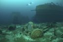
| Date: | 01 21 2011 |
|---|---|
| Description: | Underwater view of the stern of the Northerner. The timber cargo is in the hold. An archeologist is surveying and photographs the wreck off the star... |

| Date: | 01 21 2011 |
|---|---|
| Description: | Underwater view of five maritime archeologists measuring and surveying the bow of the sunken Northerner. Much of the ship appears intact, except the... |
| Date: | 05 12 2015 |
|---|---|
| Description: | Underwater view of the bow of the Pathfinder. Algae is growing along the sides, and clumps of sand are on the ship. A maritime archeologist is surve... |

| Date: | 09 29 2005 |
|---|---|
| Description: | Underwater view of an archaeologist swimming past the stern of the Rouse Simmons (also known as the Christmas tree ship). Except for the masts, the ... |

| Date: | 09 29 2005 |
|---|---|
| Description: | Underwater view of an archaeologist swimming over the windlass of the Rouse Simmons (also known as the Christmas Tree Ship). The archaeologist is sh... |

| Date: | 07 16 2007 |
|---|---|
| Description: | Underwater view of two archaeologists surveying and investigating the bow of the Rouse Simmons (also known as the Christmas Tree ship). One person i... |
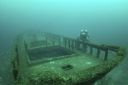
| Date: | 08 15 2014 |
|---|---|
| Description: | Underwater view of two archaeologists measuring and surveying the site of the Success. Much of the ship remains buried under sand. |
| Date: | 09 26 2014 |
|---|---|
| Description: | Underwater view of an archaeologist surveying the bilge pump of the Success. The pump is resting in a bed of sand towards the stern of the ship. Tex... |
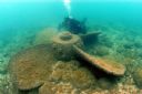
| Date: | 2006 |
|---|---|
| Description: | Underwater view of a propeller located off of the Appomattox wreck site, near Shorewood, in Lake Michigan. The diver is Kimm Stabelfeldt. |

| Date: | 1710 |
|---|---|
| Description: | A seminal and fairly accurate map of the Great Lakes Region up to Baffin's Bay in Northern Canada. This is possibly the first printed map to locate Detroit... |

| Date: | 1685 |
|---|---|
| Description: | A detailed map of the western hemisphere showing cities, settlements, Native American land, rivers, lakes, mountains, the Great Lakes, and California as an... |

| Date: | 1720 |
|---|---|
| Description: | Detailed, ornate, and comprehensive map of America from the east coast to present day Texas. Numerous features appear throughout the map, including Native ... |

| Date: | 08 2007 |
|---|---|
| Description: | An archaeologist investigates floor keelsons near the bow of the Appomattox. |
If you didn't find the material you searched for, our Library Reference Staff can help.
Call our reference desk at 608-264-6535 or email us at: