 Filter: Categories of Wisconsin Historical Images
Filter: Subject of Science
Filter: Subject of clothing and dress
Filter: Subject of land
Filter: Categories of Wisconsin Historical Images
Filter: Subject of Science
Filter: Subject of clothing and dress
Filter: Subject of land
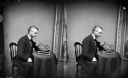
| Date: | 1871 |
|---|---|
| Description: | Stereograph portrait of Increase Allen Lapham (1811-1875) examining the sixth fragment of a 33 lb. meteorite found in Trenton, Washington County, Wisconsin... |
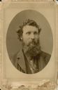
| Date: | 1875 |
|---|---|
| Description: | Head and shoulders oval framed portrait of John Muir (1838-1914). |
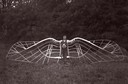
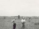
| Date: | 1909 |
|---|---|
| Description: | An unidentified man demonstrates his unsuccessful bird wing-like mechanism, which was part of an experiment in aviation. |
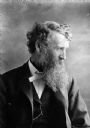
| Date: | 1899 |
|---|---|
| Description: | A studio portrait of naturalist, conservationist, and writer John Muir. |
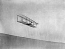
| Date: | 10 10 1902 |
|---|---|
| Description: | Wilbur Wright gliding down the steep slope of Big Kill Devil Hill at Kitty Hawk, North Carolina. Much of the Wright Brothers' success derived from the fact... |

| Date: | 1893 |
|---|---|
| Description: | Front and back covers of an advertising brochure for the New Empire line of mowers, reapers and grain binders manufactured by J.F. Seiberling & Company. Th... |
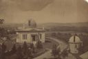
| Date: | 1880 |
|---|---|
| Description: | Elevated view of the University of Wisconsin-Madison Washburn Observatory. Hill, trees and fields are in the background. A man is standing near a small obs... |
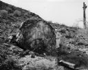
| Date: | 1953 |
|---|---|
| Description: | Stone displaying ancient writing. The rock was on the grounds of International Harvester's Phoenix Proving Grounds. Opened in 1947, the proving ground was... |
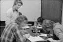
| Date: | 1978 |
|---|---|
| Description: | Students at Wausau West High School involved in an innovative science project that studied energy consumption and pollution of the Wisconsin River. |

| Date: | 1712 |
|---|---|
| Description: | Engraved double-hemispherical world map by Moll, included in his atlas The world described, or, A new and correct sett of maps: shewing the kingdoms and st... |

| Date: | 08 13 1960 |
|---|---|
| Description: | Russian delegates to the seventh International Soil Science Congress are greeted at Truax Municipal Airport. Ann Borland (left), Miss Madison, greets Mrs. ... |
| Date: | 06 1957 |
|---|---|
| Description: | Members of the Board for the Preservation of Scientific Areas inspect the Scuppernong Prairie Scientific Area. The Board furnished this photograph for the ... |

| Date: | 07 18 1955 |
|---|---|
| Description: | Five teen boys stand ankle deep in Black Earth Creek (west of Cross Plains) while working together to build a conversion dam in the creek bed. The boys are... |

| Date: | 07 18 1955 |
|---|---|
| Description: | Three teen boys work together to build up the side of the creek to stop the flowing water from washing the soil away on an edge of Black Earth Creek west o... |

| Date: | |
|---|---|
| Description: | Outdoor group portrait of men from the Forest Products Lab posed along with wooden propellers. They are posed on a hill, with trees in the background. |

| Date: | 1955 |
|---|---|
| Description: | View across water towards the "Monona-Mobile" (pontoon car) on Lake Monona, close to a pier on the left where a man is standing and watching. Buildings on ... |

| Date: | 1955 |
|---|---|
| Description: | A group of men are standing on the pontoons of the "Monona-Mobile" (pontoon car) which is near a pier on the left. The Wisconsin State Capitol is in the fa... |

| Date: | 1676 |
|---|---|
| Description: | Detailed map of North and South America. Cities, towns, forests, and mountains are shown pictorially. Duval labels regions, islands, cities, lakes, and Nat... |

| Date: | 1746 |
|---|---|
| Description: | Detailed map of the western hemisphere and part of Africa and Europe. Islands, cities, settlements, rivers, lakes, countries, and regions are marked. Mount... |

| Date: | 1684 |
|---|---|
| Description: | Map of North America showing some colonies, cities, rivers, lakes, and Native American land. Ship routes spread across both oceans, including one decorated... |
If you didn't find the material you searched for, our Library Reference Staff can help.
Call our reference desk at 608-264-6535 or email us at: