 Filter: Categories of Wisconsin Historical Images
Filter: Subject of Schools
Filter: County of Walworth
Filter: Categories of Wisconsin Historical Images
Filter: Subject of Schools
Filter: County of Walworth

| Date: | 1896 |
|---|---|
| Description: | This late 19th century map of Walworth County, Wisconsin, shows the township and range grid, towns, sections, villages and post offices, roads, railroads, ... |
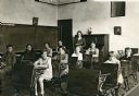
| Date: | 1930 |
|---|---|
| Description: | Ten students sitting at their desks in the classroom at Bay Hill School. Their teacher, Alice Holloway, stands at the back holding a book. Blackboards cove... |
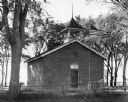
| Date: | 1946 |
|---|---|
| Description: | Dunham School, standing in a grove of trees, surrounded by a fence. The building is built of brick and has a bell tower and chimney, with a front door with... |

| Date: | 1946 |
|---|---|
| Description: | Students and teacher in the classroom at Dunham School. The room is filled with desks, chairs, books, a blackboard and a globe. Three large window can be s... |
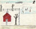
| Date: | 1945 |
|---|---|
| Description: | A group of six children play on a frozen pond on the right. The Dunham School and trees appear inside a fence on the left, and the ground is covered with s... |
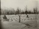
| Date: | 1932 |
|---|---|
| Description: | Identified as "A lunch counter for birds," a platform feeder has been mounted on a fence post behind Gardners Prairie School, District No. 7, Town of Sprin... |

| Date: | 1959 |
|---|---|
| Description: | This map of Lake Geneva has relief shown by contours and water depths shown by isolines. The map includes an index of schools, churches, public services, i... |

| Date: | 1858 |
|---|---|
| Description: | This map is hand-colored and mounted on cloth and shows lot and block numbers and dimensions, landownership, streets, railroads, selected buildings, fair g... |

| Date: | 1965 |
|---|---|
| Description: | This map shows proposed streets, arterial and collector streets, lot numbers and dimensions, parks, the disposal plant, a ball park, and school property. T... |

| Date: | 1890 |
|---|---|
| Description: | This map shows lot and block numbers and dimensions, landownership, city wards, buildings, streets, railroads, parks, cemeteries, churches, schools, and in... |

| Date: | 08 08 1941 |
|---|---|
| Description: | View across water of women and children sitting on the deck of the Sailing School Ship on Lake Geneva. Herb Taylor, partly obscured on the afterdeck, was t... |
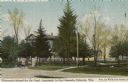
| Date: | |
|---|---|
| Description: | Hand-colored view of the drive and front gate of the Wisconsin School for the Deaf. The main building is obscured by trees. Caption reads: "Wisconsin Schoo... |
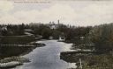
| Date: | |
|---|---|
| Description: | Elevated view of a river with grassy and tree-lined banks. The Wisconsin School for the Deaf is on a hill in the far distance beyond a bridge over the rive... |
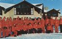
| Date: | |
|---|---|
| Description: | A group of ski instructors assembled for an outdoor group portrait. Text on reverse reads: "Every year thousands of students learn to ski in lessons fro... |
If you didn't find the material you searched for, our Library Reference Staff can help.
Call our reference desk at 608-264-6535 or email us at: