 Filter: Categories of Wisconsin Historical Images
Filter: Subject of Rural areas
Filter: Subject of social issues
Filter: Categories of Wisconsin Historical Images
Filter: Subject of Rural areas
Filter: Subject of social issues
| Date: | |
|---|---|
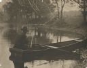
| Description: | View from shoreline of the photographer, Carl A. Peterson, taking a moment to light his pipe while fishing from a boat near the family home. |
| Date: | 1919 |
|---|---|
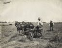
| Description: | Man on a Reynolds hay tedder pulled by team of work horses. Another man stands supervising. In the far background beyond a fence are two separate farmstead... |
| Date: | |
|---|---|
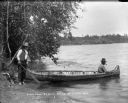
| Description: | One man sits in the bow and one man stands on shore holding the stern of a birch bark canoe at the edge of a lake. They may be Indians. The man in the cano... |

| Date: | |
|---|---|
| Description: | A group of men and boys pose by a pond. A boy holds a long, probably bamboo, fishing rod. Two men jokingly pose as if they are dancing the tango. |
| Date: | 1966 |
|---|---|
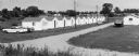
| Description: | Buildings along an unpaved road served as a camp for migrant farm workers working for the Green Bay Food Company. In 1946, more than 4,000 farmworkers fr... |

| Date: | 1967 |
|---|---|
| Description: | A seated young man looking into the camera watches over polls during a historic union election in Neshkoro. In the center, the ballot box is placed in fron... |
| Date: | 1969 |
|---|---|
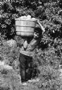
| Description: | A child worker wearing a short sleeve plaid shirt, dark pants and no shoes is carrying grapefruit from a Texas grove on his shoulder. He is looking into th... |
| Date: | 1967 |
|---|---|
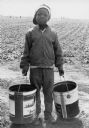
| Description: | A nine-year old Jamaican boy wearing a backwards cap, plaid jacket, jeans, and sneakers. He is holding two buckets and is looking at the camera. He is join... |
| Date: | 1969 |
|---|---|
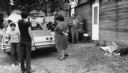
| Description: | A migrant worker family stands in front of a parked vehicle and a cabin that serves as temporary housing in a Wautoma labor camp. Some of the children are ... |

| Date: | 08 24 1967 |
|---|---|
| Description: | Elevated view of 150 workers rallying as a part of Obreros Unidos (United Workers) protest against poor working conditions of migrant farm workers in the S... |

| Date: | |
|---|---|
| Description: | Stereograph of two men lying on the beach, and three rowboats at the shore. Text at right: "A Trip Through the Dells of the Wisconsin River." |
| Date: | 07 1965 |
|---|---|
| Description: | A man stands on the road outside a home shortly after civil rights volunteers depart from canvassing. "Leaving a house (on the right) after canvassing. B... |
| Date: | 07 1965 |
|---|---|
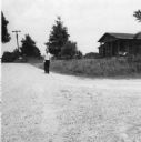
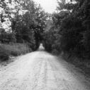
| Description: | A rural road canvassed and photographed by a civil rights volunteer. "'A country mile' - one road to canvass in Summit, Miss. Actually the shaded part of... |
| Date: | 07 1965 |
|---|---|
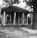
| Description: | A home canvassed by a civil rights volunteer. "One of the 'better' homes that was canvassed in Summit. This one could also represent many homes in Hattie... |
| Date: | 07 1965 |
|---|---|
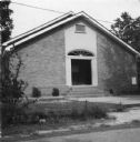
| Description: | A church building photographed by a civil rights volunteer. "The 4th Sunday church of Summit. Rev. Ned Taylor, pastor. After church, Rev. Taylor invited ... |

| Date: | 07 1965 |
|---|---|
| Description: | A rural schoolhouse photographed by a civil rights volunteer. "A Negro school located outside Gillsburg, Miss. Photographed on our trip to return two MFD... |

| Date: | 07 1965 |
|---|---|
| Description: | An African-American church building located near the African American school, as photographed by a civil rights volunteer. "Photographed on our trip to r... |
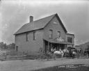
| Date: | 1909 |
|---|---|
| Description: | Six men, a young boy and a woman stand outside on the porch and road in front of the General Store. There is a sign for "Star Brand Shoes" posted on the ro... |

| Date: | 1770 |
|---|---|
| Description: | The south west sheet of a four sheet map of Virginia, showing the counties, mountains, rivers, court houses, a few cities, and mills. A few Plantations ar... |

| Date: | 1780 |
|---|---|
| Description: | This map shows the townships, parishes, cities, towns, plantations, lakes, rivers, swamps, and roads near the coast of South Carolina and Georgia. Emphasis... |
If you didn't find the material you searched for, our Library Reference Staff can help.
Call our reference desk at 608-264-6535 or email us at: