 Filter: Categories of Wisconsin Historical Images
Filter: Subject of Rural areas
Filter: Type of Map or Atlas
Filter: Subject of rivers
Filter: Categories of Wisconsin Historical Images
Filter: Subject of Rural areas
Filter: Type of Map or Atlas
Filter: Subject of rivers

| Date: | 08 1960 |
|---|---|
| Description: | This map shows a detailed account of southwestern Wisconsin. Individual settlers, the type of trees that grow in given areas, the quality of the soil (labe... |
| Date: | 1900 |
|---|---|
| Description: | This map shows the distances and land use and type along the road from Green Bay to Racine. A few places are labeled, including Devil River, Sheboygan Rive... |
| Date: | 1900 |
|---|---|
| Description: | This map shows distances, land use, and landowners along the road from Racine to Janesville. The map is divided into several sheets with north typically or... |

| Date: | 1790 |
|---|---|
| Description: | This map of the north eastern states shows roads, rivers, lakes, waterfalls, mountains, cities, forts, mills, the Oneida Reservation, and "New York Donatio... |

| Date: | 1770 |
|---|---|
| Description: | The south west sheet of a four sheet map of Virginia, showing the counties, mountains, rivers, court houses, a few cities, and mills. A few Plantations ar... |

| Date: | 1776 |
|---|---|
| Description: | Map of New Jersey and New York, showing cities, forts, roads, counties, townships, land grants, rivers, lakes and several topographical features. Much of t... |

| Date: | 1790 |
|---|---|
| Description: | An ink and hand-colored map, showing the land and landowners of the Susquehanna company purchase in Pennsylvania. Rivers are shown and occasionally labeled... |

| Date: | 1780 |
|---|---|
| Description: | This map shows the townships, parishes, cities, towns, plantations, lakes, rivers, swamps, and roads near the coast of South Carolina and Georgia. Emphasis... |

| Date: | 1793 |
|---|---|
| Description: | Detailed topographical map of the Ohio River between Clarkville and Louisville. It shows plots of farmland, forest, islands, garden plots, houses, Fort Fe... |
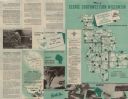
| Date: | 1953 |
|---|---|
| Description: | This map shows the locations of many scenic areas in La Crosse, Vernon, Crawford, Richland, Grant, and Iowa Counties. On the front side of the map, there i... |

| Date: | 1901 |
|---|---|
| Description: | Plat map showing land ownership of Township 21N Range 3W in Jackson County for 1901. Scale is 2 inches to 1 mile. |
If you didn't find the material you searched for, our Library Reference Staff can help.
Call our reference desk at 608-264-6535 or email us at: