Filter: Categories of Wisconsin Historical Images
Filter: Subject of Roads
Filter: Year of 1800-1899
Filter: County of Waukesha
Filter: Categories of Wisconsin Historical Images
Filter: Subject of Roads
Filter: Year of 1800-1899
Filter: County of Waukesha

| Date: | 1885 |
|---|---|
| Description: | Bird's-eye map of Oconomowoc. |

| Date: | 1886 |
|---|---|
| Description: | Bird's-eye map of Menomonee Falls. |

| Date: | 1857 |
|---|---|
| Description: | Elevated view of Waukesha with two women wearing dresses with a boy in long pants and tam o'shanter hat in foreground against a split-rail fence. Beyond th... |

| Date: | 1880 |
|---|---|
| Description: | Bird's-eye map of Waukesha, county seat of Waukesha County. |

| Date: | 1870 |
|---|---|
| Description: | Birds-eye drawing of Oconomowoc depicts street names and street layouts, houses, trees, Oconomowoc River, Fowler Lake, and La Belle Lake. A reference key a... |

| Date: | 1890 |
|---|---|
| Description: | Colored bird's-eye map of Oconomowoc and the Lake Region, Waukesha County. Looking North from Government Hill. Location key below image identifies 24 Hotel... |
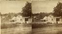
| Date: | 1877 |
|---|---|
| Description: | Stereograph view of Glenn's mineral spring. |

| Date: | 1873 |
|---|---|
| Description: | This late 19th century map shows the lake region around Oconomowoc in Waukesha County and eastern Jefferson County, Wisconsin. The township and range grid,... |

| Date: | 1887 |
|---|---|
| Description: | This late 19th century map shows the lake region around Oconomowoc in Waukesha County and eastern Jefferson County, Wisconsin. Cities and villages, roads, ... |

| Date: | 1896 |
|---|---|
| Description: | Map shows landownership and acreages, roads, and townships. |

| Date: | 1840 |
|---|---|
| Description: | This manuscript map by Increase Lapham shows the railroads, roads, wetlands, lakes and streams, dams, prairies, and settlers in the eastern half of Waukesh... |

| Date: | 1898 |
|---|---|
| Description: | Map showing the contour depths of the lakes in northwestern Waukesha County, Wisconsin. Roads, railroads, depots, churches, schools, and hotels in the area... |

| Date: | 1873 |
|---|---|
| Description: | Plat map of the township of Eagle (T5N, R17E) at a scale of 2 inches to one mile. |

| Date: | 1859 |
|---|---|
| Description: | This hand-colored map shows township and range in pink, blue, yellow, and orange, land ownership, includes 16 city inset maps showing land ownership, and 5... |
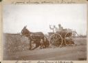
| Date: | 1895 |
|---|---|
| Description: | Two men are riding in an open carriage pulled by a donkey. Captions written on the front of the photograph describe "A joyous Sunday afternoon at Pine Lake... |
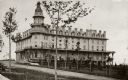
| Date: | 1895 |
|---|---|
| Description: | A view of the two and one-half story wood frame house built by George Brumder in 1893 on Pine Lake. There are two chimneys, and decorative ironwork on the ... |

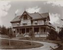
| Date: | 1895 |
|---|---|
| Description: | Tall posts with an overhead sign reading "Villa Henrietta" mark the gated entrance to George Brumder's Pine Lake estate. There is a smaller gate for pedest... |
If you didn't find the material you searched for, our Library Reference Staff can help.
Call our reference desk at 608-264-6535 or email us at: