Filter: Categories of Wisconsin Historical Images
Filter: Subject of Roads
Filter: Subject of michigan, lake
Filter: Categories of Wisconsin Historical Images
Filter: Subject of Roads
Filter: Subject of michigan, lake

| Date: | 1874 |
|---|---|
| Description: | This map shows lakes, rivers, state, county, and town boundaries, as well as railroads completed, in progress, and contemplated. The map includes a color d... |

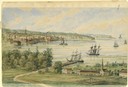
| Date: | 1853 |
|---|---|
| Description: | Bird's-eye map of Milwaukee looking east toward Lake Michigan from a bluff, long since graded into a slope, at about 6th Street between Wisconsin Avenue an... |

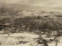
| Date: | 11 16 2001 |
|---|---|
| Description: | Aerial view of General Mitchell International in Milwaukee, looking southeast to the Lake Michigan shoreline. |

| Date: | 1898 |
|---|---|
| Description: | Bird's-eye map, looking west from shoreline on Lake Michigan of Milwaukee to Golden Lake in Waukesha County, with Kenosha and Fox Point at bottom corners, ... |

| Date: | 1927 |
|---|---|
| Description: | Color map, hand-drawn with comic figures engaged in various activities throughout map. Bordered by the river on the left and Lake Michigan on the right, in... |

| Date: | 1879 |
|---|---|
| Description: | Bird's-eye map of Two Rivers. |

| Date: | 1857 |
|---|---|
| Description: | From Judge Smith Addition, 5th Ward, looking north, toward the city. Drawing is an elevated view of field and plank fence in foreground, road to the left a... |

| Date: | 1854 |
|---|---|
| Description: | Bird's-eye view of Milwaukee looking east toward Lake Michigan from a bluff, long since graded into a slope, at about 6th Street between Wisconsin Avenue a... |

| Date: | 1937 |
|---|---|
| Description: | Bird's-eye view of Milwaukee in 1853 details building features and city layout from southwest. Important buildings are numbered in a silhouette drawing bel... |
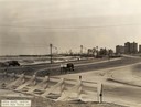
| Date: | 1933 |
|---|---|
| Description: | View from Outer Lake Shore Drive looking south from Foster Avenue. Lake Michigan and the Chicago skyline are in the background. |
| Date: | 1936 |
|---|---|
| Description: | Crescent Beach campsite with cabins and miniature golf course by Lake Michigan. |

| Date: | 05 15 1897 |
|---|---|
| Description: | Elevated view of the Chicago & Northwestern Railway yards looking northwest. The elevator of the Northern Grain Company is in the middle distance. |
| Date: | 1858 |
|---|---|
| Description: | View from the second story of the Salesianum, the residence of Dr. Salzmann. The view includes Lake Michigan, the Milwaukee shoreline, and some of the nume... |
| Date: | |
|---|---|
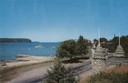
| Description: | Eagle Harbor, looking west, with boats anchored in the harbor. In the foreground are the stone pillars of the village fire station. |

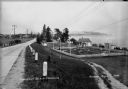
| Date: | 1910 |
|---|---|
| Description: | View from hill towards downtown Fish Creek, with the buildings and ground covered in snow. There is a road in the foreground leading off to the left. The b... |
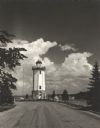
| Date: | 1954 |
|---|---|
| Description: | View down road towards the Fond du Lac lighthouse, built in 1933. There are cumulus clouds in the sky, and pine trees are lining the shore. |
If you didn't find the material you searched for, our Library Reference Staff can help.
Call our reference desk at 608-264-6535 or email us at: