 Filter: Categories of Wisconsin Historical Images
Filter: Subject of Roads
Filter: Subject of menominee indians
Filter: Categories of Wisconsin Historical Images
Filter: Subject of Roads
Filter: Subject of menominee indians
| Date: | |
|---|---|
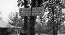
| Description: | A toll road sign on the Keshena Menominee Reservation for the Highway 55 toll road that goes through the reservation. |
| Date: | 1933 |
|---|---|
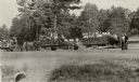
| Description: | Native Americans hired to assist with the White Pine Blister Rust eradication effort on the Menominee Reservation are being trucked to their work site. |
| Date: | 1935 |
|---|---|
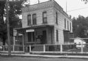
| Description: | U.S. Department of the Indian agency building on the Menominee Indian Reservation. |

| Date: | 04 1954 |
|---|---|
| Description: | A young Menominee Indian (Charles ?) pauses briefly for a photograph while straddling his bicycle. He is stopped on the road with the snow-covered Wolf Riv... |

| Date: | 1938 |
|---|---|
| Description: | This map shows lakes, rivers, roads, trails, lookout towers, and railroads. |

| Date: | 1855 |
|---|---|
| Description: | This map shows the entire state and part of the Upper Peninsula of Michigan. It depicts creeks, rivers, lakes, railroads completed, railroads in progress, ... |

| Date: | 1855 |
|---|---|
| Description: | This Wisconsin map depicts counties, creeks, rivers, lakes, railroads completed, railroads in progress, common roads and the Menomonee Reservation. |

| Date: | 1855 |
|---|---|
| Description: | This map depicts counties, creeks, rivers, lakes, railroads completed, railroads in progress, common roads and the Menomonee Reservation. |

| Date: | 1856 |
|---|---|
| Description: | This map with an ornamental border shows the township survey grid and identifies counties, named towns, cities and villages, rivers, lakes, railroads, road... |

| Date: | 1856 |
|---|---|
| Description: | This map of shows the township survey grid and identifies counties, named towns, cities and villages, rivers, lakes, railroads, roads, and the Menomonee an... |

| Date: | 1857 |
|---|---|
| Description: | This map depicts the township survey grid and identifies counties, named towns, cities and villages, rivers, lakes, railroads, roads, and the Menomonee and... |

| Date: | 1858 |
|---|---|
| Description: | This map of the entire state of Wisconsin depicts the township survey grid and identifies counties, named towns, cities and villages, rivers, lakes, railro... |

| Date: | 1859 |
|---|---|
| Description: | This map of the entire state of Wisconsin depicts the township survey grid and identifies counties, named towns, cities and villages, rivers, lakes, railro... |

| Date: | 09 17 1959 |
|---|---|
| Description: | A map of the Menominee Indian Reservation that shows the highways, different types of roads, rivers and streams in the area. |

| Date: | 1993 |
|---|---|
| Description: | A series of three maps showing the lands of the Menominee, the first of these three maps shows the present-day Menominee Indian Reservation. Highways and r... |

| Date: | 1933 |
|---|---|
| Description: | This map shows the township and range system, sections, cities and villages, schools, roads, railroads, and lakes and streams in Shawano County, which at t... |

| Date: | 2013 |
|---|---|
| Description: | Map is the most extensive endeavor to date to accurately locate and document both prehistoric place names and natural features of the Menominee language wi... |

| Date: | 1939 |
|---|---|
| Description: | This illustrated map shows counties, highways, rivers, roads, present and proposed state parks and forests, proposed state parkways, proposed state monumen... |

| Date: | 1956 |
|---|---|
| Description: | This map shows reservation boundaries, U.S. township lines, highways, roads, rivers, and lakes. The lower left corner of the map includes a legend of "Conv... |

| Date: | 1907 |
|---|---|
| Description: | This blueprint map shows a proposed plan for pleasure roads and reservation system. It also shows schools, cemeteries, old river channel, proposed bridge, ... |
If you didn't find the material you searched for, our Library Reference Staff can help.
Call our reference desk at 608-264-6535 or email us at: