Filter: Categories of Wisconsin Historical Images
Filter: Subject of Roads
Filter: Subject of cemeteries
Filter: Categories of Wisconsin Historical Images
Filter: Subject of Roads
Filter: Subject of cemeteries
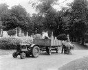
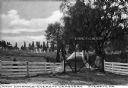
| Date: | 1935 |
|---|---|
| Description: | Workers tending the grounds of the Forest Home Cemetery using a McCormick-Deering I-12 tractor and wagon. |
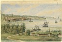
| Date: | 1858 |
|---|---|
| Description: | View from the second story of the Salesianum, the residence of Dr. Salzmann. The view includes Lake Michigan, the Milwaukee shoreline, and some of the nume... |

| Date: | 05 10 1928 |
|---|---|
| Description: | The Lutheran Church and buildings, seen from Lutheran Church Hill. |

| Date: | 02 06 1948 |
|---|---|
| Description: | Aerial photograph of Madison's west side looking northeast along Speedway Road. Visible are Forest Hill and Resurrection Cemeteries, West High School, Hoyt... |

| Date: | 02 06 1948 |
|---|---|
| Description: | Aerial view of west side, looking south along Glenway Street. Visible are the reservoir, Lake Wingra, Forest Hill and Resurrection Cemetery, Hoyt Park. Maj... |

| Date: | 02 06 1948 |
|---|---|
| Description: | Aerial photograph looking northwest across the reservoir on Glenway Street. Featured are Hoyt and Quarry Parks, Resurrection Cemetery. Major streets are Fr... |

| Date: | 02 06 1948 |
|---|---|
| Description: | Looking north along Glenway Street. Visible are the reservoir, Hoyt and Quarry Parks, Resurrection and Forest Hill Cemeteries, Rentschler Greenhouses, Fore... |

| Date: | 02 06 1948 |
|---|---|
| Description: | Looking southeast across Speedway Road. Visible are the reservoir on Glenway Street, Hoyt Park, Resurrection and Forest Hill cemeteries, Glenway Golf cours... |

| Date: | 02 06 1948 |
|---|---|
| Description: | Looking east along Regent Street with snow on the ground. Visible are Lake Wingra, Monona Bay, railroad causeway across Monona, Lake Mendota, Hoyt Park, We... |
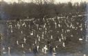
| Date: | |
|---|---|
| Description: | Elevated view of various groups of people in a cemetery. A small group of people are gathered around a grave in the foreground. Other small groups are walk... |
| Date: | 09 30 1949 |
|---|---|
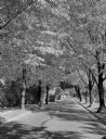
| Description: | Fall scene looking east in the 2600 block of Regent Street along the Catholic cemetery. |
| Date: | 07 25 1925 |
|---|---|
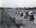
| Description: | A line of International trucks are parked in a line along a dirt road lined with fences and power lines. Each truck has a load of dirt, and metal forms are... |
| Date: | |
|---|---|
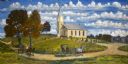
| Description: | A depiction of the Yellowstone Church of rural Lafayette County, just a few miles from the Kammerude farm. The church is built from locally quarried limest... |

| Date: | |
|---|---|
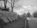
| Description: | A view of the church from the side, as well as a view of the grounds, which includes a cemetery. An iron fence surrounds the grounds, with both carriage an... |
| Date: | |
|---|---|
| Description: | A view of eight commemorative tablets at the North Cemetery of Antietam Battlefield, the site of the bloodiest one-day battle in United States history in 1... |

| Date: | 1913 |
|---|---|
| Description: | A wall atlas of Sauk County, Wisconsin, displaying its 22 towns. On the left side are advertisements for local businesses. |
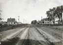
| Date: | 05 30 1916 |
|---|---|
| Description: | View down center of rural dirt road with houses along both sides in Black Hawk County. A man and horse are in a field on the left, near a sign that says: "... |

| Date: | |
|---|---|
| Description: | View down a dirt road leading to Mount Equinox in the background. A church is in the valley near the road, and a cemetery is located on the other side of... |
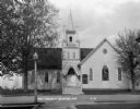
| Date: | 1931 |
|---|---|
| Description: | Exterior view from across street of the church. It has a bell steeple, stained glass windows, double french doors with an archway, and a wall gable facade.... |
If you didn't find the material you searched for, our Library Reference Staff can help.
Call our reference desk at 608-264-6535 or email us at: