 Filter: Categories of Wisconsin Historical Images
Filter: Subject of Rivers
Filter: County of Crawford
Filter: Categories of Wisconsin Historical Images
Filter: Subject of Rivers
Filter: County of Crawford
| Date: | |
|---|---|
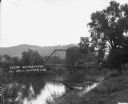
| Description: | View from shoreline of a car driving over a bridge on the Kickapoo River. There is a ridge of a hill in the background. |
| Date: | |
|---|---|
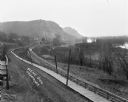
| Description: | View down hill of a bridge across a river. There are railroad tracks going along the shoreline under the bridge. |
| Date: | |
|---|---|
| Description: | Elevated view of a road, wooden boardwalk and railroad tracks leading towards a group of buildings near bluffs in the distance. On the right is a marshy ar... |
| Date: | |
|---|---|
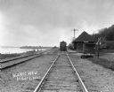
| Description: | Locomotive at the De Soto depot on the Chicago, Burlington and Quincy Railroad line. The Mississippi River is on the left. |

| Date: | |
|---|---|
| Description: | View down a wooden pedestrian walkway. The Mississippi River and railroad tracks are along the shoreline on the left. Storefronts and other buildings are a... |

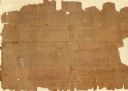
| Date: | 1830 |
|---|---|
| Description: | This early 19th century manuscript map of Prairie du Chien, Wisconsin, shows sections, landownership and acreages, roads, and ferries in the towns of Bridg... |
| Date: | |
|---|---|
| Description: | These 19th-century manuscript maps show the survey of much of Crawford County, Wisconsin. Plats for the towns of Prairie du Chien and Bridgeport and for th... |

| Date: | 01 09 1849 |
|---|---|
| Description: | Shows county line boundaries, rivers, and falls. Includes explanation of township and county divisions. Pen and pencil on paper. Title supplied by cataloge... |

| Date: | 1911 |
|---|---|
| Description: | Blue line print. Shows post offices, houses, schools, churches, roads, routes, rivers, and railroads. Includes explanation of symbols. "H.G.M. October 12,... |

| Date: | 1926 |
|---|---|
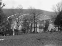
| Description: | View from hill looking down at homes and businesses in town. A bridge goes over the Kickapoo River. The depot and railroad tracks and Main Street are behin... |

| Date: | 1890 |
|---|---|
| Description: | This is a plat map of "Wauzeeka" drawn in pencil. The map shows numbered lots, labeled streets, the Kickapoo River, and railroads. The map reads: "Laid out... |

| Date: | 1856 |
|---|---|
| Description: | This map shows lot and block numbers, streets, a mill, the Milwaukee and Mississippi Railroad, the train depot, and the Kickapoo River. Included in the low... |

| Date: | 05 21 1855 |
|---|---|
| Description: | This plat map shows lots, the Kickapoo River, and the Wisconsin River. |
| Date: | 1856 |
|---|---|
| Description: | This map is ink and watercolor on paper and includes certifications inscribed by Saml. T. [M?]ight, a civil engineer, Edward H. Brodhead, James H. Lockwood... |

| Date: | 1856 |
|---|---|
| Description: | This map is ink and color on paper and mounted on cloth. The map shows lot and block numbers, streets, a railroad, and the Kickapoo River. Some lots are c... |

| Date: | |
|---|---|
| Description: | This map is pen-and-ink on tracing paper with a mounted legend and shows the Kickapoo River, Indian mounds, the 1st Fort Crawford, an Indian Agency, the si... |
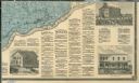
| Date: | 1878 |
|---|---|
| Description: | The bottom right corner of a map of Crawford County. This portion of the map includes town directories and illustrations of the Court House in Prairie Du C... |
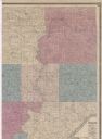
| Date: | 1878 |
|---|---|
| Description: | Portion of a map of Crawford County. |

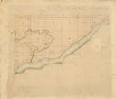
| Date: | 1900 |
|---|---|
| Description: | This map shows a line, marked with latitude and longitude coordinates that runs through Prairie du Chien. Only a few features beyond this line are displaye... |

| Date: | 1900 |
|---|---|
| Description: | This photocopy map shows marshes, woods, buildings, and selected features including islands, mounds, old Fort Crawford, and "new site for a fort in questio... |
If you didn't find the material you searched for, our Library Reference Staff can help.
Call our reference desk at 608-264-6535 or email us at: