Filter: Categories of Wisconsin Historical Images
Filter: Subject of Rivers
Filter: Community of Prairie du Chien
Filter: Categories of Wisconsin Historical Images
Filter: Subject of Rivers
Filter: Community of Prairie du Chien

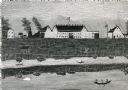
| Date: | 1870 |
|---|---|
| Description: | During the War of 1812, the only battle fought in Wisconsin was in Prairie du Chien, in 1814. Made fifty-six years later, this birds eye drawing depicts th... |
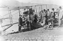
| Date: | 10 19 1911 |
|---|---|
| Description: | Pilot Hugh Robinson and his Curtiss hydroplane at Prairie du Chien during a flight that was intended to be the first all the way down the Mississippi River... |

| Date: | |
|---|---|
| Description: | 1. Stone Astor Fur Co. building built in 1808. 2. Voth Cottage, built in 1930. 3. Brisbois mansion, built 1808, by Michael Brisbois. 4. Site of Hudson Bay ... |

| Date: | 1814 |
|---|---|
| Description: | Fort Shelby, built by the Americans during the War of 1812. In 1814 the fort surrendered to British forces led by Captain Andrew W. Bulger who renamed it F... |

| Date: | 1840 |
|---|---|
| Description: | A view of Fort Crawford (the second site and buildings of 1829-?). |
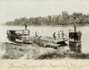
| Date: | 1895 |
|---|---|
| Description: | Prairie du Chien (vicinity) about 1895-1900. Shell buyers with their launches and barges docked at shoreline. Freshwater clam shells were used in the pearl... |

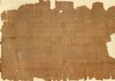
| Date: | 1820 |
|---|---|
| Description: | This map displays the plan for claiming various settlement zones in the Prairie des Chiens area in 1820. It shows Fort Crawford and 87 confirmed and unconf... |

| Date: | 1830 |
|---|---|
| Description: | This early 19th century manuscript map of Prairie du Chien, Wisconsin, shows sections, landownership and acreages, roads, and ferries in the towns of Bridg... |

| Date: | 05 21 1855 |
|---|---|
| Description: | This plat map shows lots, the Kickapoo River, and the Wisconsin River. |
| Date: | 1856 |
|---|---|
| Description: | This map is ink and watercolor on paper and includes certifications inscribed by Saml. T. [M?]ight, a civil engineer, Edward H. Brodhead, James H. Lockwood... |

| Date: | |
|---|---|
| Description: | This map is pen-and-ink on tracing paper with a mounted legend and shows the Kickapoo River, Indian mounds, the 1st Fort Crawford, an Indian Agency, the si... |

| Date: | 1900 |
|---|---|
| Description: | This map shows a line, marked with latitude and longitude coordinates that runs through Prairie du Chien. Only a few features beyond this line are displaye... |

| Date: | 1900 |
|---|---|
| Description: | This photocopy map shows marshes, woods, buildings, and selected features including islands, mounds, old Fort Crawford, and "new site for a fort in questio... |
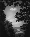
| Date: | 1950 |
|---|---|
| Description: | Elevated view of the Wisconsin River from Wyalusing State Park, framed by trees. There is a bridge over the river in the distance. |
If you didn't find the material you searched for, our Library Reference Staff can help.
Call our reference desk at 608-264-6535 or email us at: