 Filter: Categories of Wisconsin Historical Images
Filter: Subject of Rivers
Filter: Creator Name of Unknown
Filter: County of Oneida
Filter: Categories of Wisconsin Historical Images
Filter: Subject of Rivers
Filter: Creator Name of Unknown
Filter: County of Oneida

| Date: | 1923 |
|---|---|
| Description: | Map of Oneida County-Rhinelander Airport which was laid out at the county fairgrounds. The map appears on the reverse side of a letter Roy Larson received ... |
| Date: | |
|---|---|
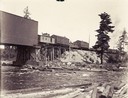
| Description: | View from shoreline towards the Soo Line railroad bridge crossing the Tomahawk River at Bradley, Wisconsin. The bridge, built in 1886, was 126 ft. long and... |
| Date: | 1935 |
|---|---|
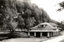
| Description: | Wisconsin Conservation Department fish hatchery near Woodruff. |
| Date: | 1895 |
|---|---|
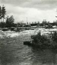
| Description: | Crew of river drivers moving logs off of rocks below a dam probably on the Wisconsin River. |
| Date: | 1890 |
|---|---|
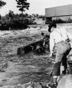
| Description: | Log driving crew maneuvering logs through rapids below a dam, probably on the Wisconsin River. |

| Date: | 1900 |
|---|---|
| Description: | This map shows logging roads, railroads with spur lines, trails, rapids, lumber camps, Indian villages, summer resort, lakes, rivers, and ponds. |

| Date: | |
|---|---|
| Description: | A plat map drawn in blue and red ink of township No. 43 North of Range No. 4 East of 4th Meridian. |
If you didn't find the material you searched for, our Library Reference Staff can help.
Call our reference desk at 608-264-6535 or email us at: