 Filter: Categories of Wisconsin Historical Images
Filter: Subject of Real estate development
Filter: Categories of Wisconsin Historical Images
Filter: Subject of Real estate development

| Date: | 06 1837 |
|---|---|
| Description: | Pen-and-ink on paper. Shows riverside property west of the Milwaukee River. Inscribed by several early Milwaukee settlers, including Henry W. Cleveland, Cy... |

| Date: | 06 11 1958 |
|---|---|
| Description: | Paperwork is completed for Northland Manor Development Corporation to open an affiliate in Madison. Left to right: William Pessin (Milwaukee builder); Arth... |

| Date: | 1874 |
|---|---|
| Description: | Map shows townships and sections, landownership and acreages, railroads, and roads. The map was compiled by the civil engineer and city surveyor agent H.I.... |
| Date: | 1960 |
|---|---|
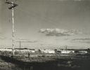
| Description: | New residential construction on the outer southwest edge of Madison. |

| Date: | 1939 |
|---|---|
| Description: | This is a zoning map of Wauwatosa with a key of districts including agricultural, resident, business, commercial, and industrial. The map features labeled ... |

| Date: | 1874 |
|---|---|
| Description: | This map of La Crosse is accompanied by other plats of subdivision of the city. The relief is shown by hachures. The additions include: Rudolf Gripps Addit... |

| Date: | |
|---|---|
| Description: | Aerial view of Vieth's Park subdivision on the north shore of Lake Mendota. |

| Date: | 10 30 1915 |
|---|---|
| Description: | Outdoor group portrait of people identified as "settlers" (lot buyers) to the Nakoma development. Many of the people are wearing or holding a long-stemmed ... |

| Date: | 1918 |
|---|---|
| Description: | This is a collection of two maps. One map is blue line print that includes illustrations and shows the location of buildings, gardens, plant life, and spri... |

| Date: | 11 05 1963 |
|---|---|
| Description: | A bulldozer demolishing St. Joseph's Catholic Church at 10 South Park Street as part of the Triangle area urban renewal project. |

| Date: | 01 31 1964 |
|---|---|
| Description: | Aerial view of University Hill Farms area which has grown from a cow pasture to a square-mile housing and business area. 4,000 people live in 750 single-fa... |

| Date: | 1900 |
|---|---|
| Description: | This photostat map was probably originally created in 1835 and shows in addition to private claims, mills, roads, and trails. Green Bay and the Fox River a... |

| Date: | 1900 |
|---|---|
| Description: | This photocopied map shows private claim owners, buildings, and land use in 1818. Insets show Fort Howard and the caption reads: "A view of the Fox River ... |

| Date: | 1880 |
|---|---|
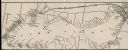
| Description: | This map covers parts of Minnesota, Iowa, and South Dakota and advertised 1,000,000 acres of land available. Communities, roads, and railroad lines are lab... |

| Date: | 12 01 1964 |
|---|---|
| Description: | A bulldozer demolishing five homes in the four hundred block of West Washington Avenue to make room for a six-story office building to be the Wisconsin hea... |
| Date: | 1900 |
|---|---|
| Description: | A map of Lake Geneva, including the villages of Williams Bay and Fontana, and a portion of the city of Lake Geneva. The Chicago and Northwestern Railway li... |

| Date: | 12 16 1964 |
|---|---|
| Description: | View of a crane about to swing a wrecking ball into a building wall at the 30 W. Mifflin Street and Carroll Street corner of the Square as a crowd is looki... |

| Date: | 1891 |
|---|---|
| Description: | This blueprint manuscript map shows land owned by Green Bay & Mississippi Canal Co., Meade, Vilas, Patten, and Hewitt. Streets and the Fox River are labele... |

| Date: | 05 26 1965 |
|---|---|
| Description: | Stanly Sirotin is posing in front of the corner of the "30 On the Square" sky scraper. The low, steep angle of the photographer's camera, looking up, revea... |

| Date: | 1920 |
|---|---|
| Description: | This bird's-eye-view map shows plat of area, numbered blocks and lots, local streets, roads, parks, golf club, schools, buildings, landscaping, and part of... |
If you didn't find the material you searched for, our Library Reference Staff can help.
Call our reference desk at 608-264-6535 or email us at: