 Filter: Categories of Wisconsin Historical Images
Filter: Subject of Railroads
Filter: Subject of monuments
Filter: Categories of Wisconsin Historical Images
Filter: Subject of Railroads
Filter: Subject of monuments

| Date: | 1943 |
|---|---|
| Description: | Elevated view of Wisconsin Avenue, looking east from Court of Honor. Caption reads: "Court of Honor, Looking East, Milwaukee, Wisconsin." |

| Date: | 1882 |
|---|---|
| Description: | Plat map of the village of Dunbarton, received by the Lafayette County Register's Office on September 22, 1892. Certification by the surveyor, Albert Pool,... |

| Date: | 1861 |
|---|---|
| Description: | This map shows lot and block numbers, piers, streets, monuments, and township section corners. Included is a note on the width of avenues, piers, slips, al... |

| Date: | 1872 |
|---|---|
| Description: | This map shows wards, roads, railroads, lot and block numbers, subdivisions, parks, some landownership, and a race course. Manuscript annotations in red in... |

| Date: | 1880 |
|---|---|
| Description: | This map shows wards, roads, railroads, lot and block numbers, subdivisions, parks, and some landownership. A handwritten annotation in red reads: "Note: S... |

| Date: | 05 24 1952 |
|---|---|
| Description: | The Wisconsin School for Boys Band, under the direction of Arnold Krueger, provided the musical entertainment for the dedication ceremony of the Waukesha D... |
| Date: | 10 03 1955 |
|---|---|
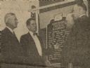
| Description: | Dr. Clifford L. Lord (second from left), director of the Wisconsin State Historical Society, unveiled the Wisconsin Central Railroad historical marker at H... |

| Date: | 1936 |
|---|---|
| Description: | This colored road map shows automobile roads in Wisconsin as well as portions of Michigan, Iowa, Minnesota, and Illinois. U.S. numbered highways are shown ... |

| Date: | 1936 |
|---|---|
| Description: | This colored road map shows automobile roads in Wisconsin as well as portions of nearby states. Information on the quality and type of any given road (pave... |
If you didn't find the material you searched for, our Library Reference Staff can help.
Call our reference desk at 608-264-6535 or email us at: