Filter: Categories of Wisconsin Historical Images
Filter: Subject of Railroads
Filter: County of Waukesha
Filter: Year of 1900-1999
Filter: Categories of Wisconsin Historical Images
Filter: Subject of Railroads
Filter: County of Waukesha
Filter: Year of 1900-1999
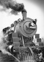
| Date: | 07 07 1984 |
|---|---|
| Description: | Steam locomotive No. 1385 moves along the tracks as part of the Butler Railroad Days. |
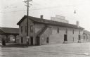
| Date: | 03 22 1922 |
|---|---|
| Description: | Exterior view of the Chicago, Milwaukee, and St. Paul freight station. |
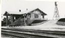
| Date: | 1916 |
|---|---|
| Description: | Chicago, Milwaukee, and St. Paul Railway depot. Side view of depot with windmill in background. |
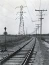
| Date: | 03 1928 |
|---|---|
| Description: | Power lines along both sides of railroad tracks running through a rural area. |

| Date: | 1934 |
|---|---|
| Description: | This map of Waukesha County, Wisconsin, from the Wisconsin Land Inventory shows the township and range grid, sections, cities and villages, vegetation type... |

| Date: | 1953 |
|---|---|
| Description: | Map shows landownership and acreages, roads, and railroads in the Town of Waukesha and part of the city of Waukesha, Waukesha County, Wisconsin. |

| Date: | 02 1956 |
|---|---|
| Description: | This 1956 map of Waukesha County, Wisconsin, shows the township and range grid, towns, sections, cities and villages, roads, railroads, dams, airports, par... |

| Date: | 1930 |
|---|---|
| Description: | This map of Waukesha County, Wisconsin, from the 1930s shows the township and range grid, towns, sections, cities and villages, highways and roads, railroa... |

| Date: | 1911 |
|---|---|
| Description: | This 1911 map from the U.S. Post Office Dept. shows rural delivery routes, active and discontinued post offices, selected rural landowners and houses, chur... |

| Date: | 1954 |
|---|---|
| Description: | This map of Waukesha shows numbered ward boundaries, roads, and some buildings. The bottom of the map includes a street index. |
| Date: | 1925 |
|---|---|
| Description: | This map shows township sections, roads, railroads, and lakes. The map also features extensive manuscript annotations noting landownership in pencil. Stamp... |

| Date: | 1980 |
|---|---|
| Description: | This map shows schools, hotels, stations, roads, railroads, reefs, and public buildings. The upper right corner includes "A Summer and Winter Guide for Spo... |

| Date: | 05 24 1952 |
|---|---|
| Description: | The Wisconsin School for Boys Band, under the direction of Arnold Krueger, provided the musical entertainment for the dedication ceremony of the Waukesha D... |
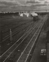
| Date: | 1950 |
|---|---|
| Description: | Elevated view of parallel tracks in a railroad yard, with a locomotive pulling a boxcar. A man is standing near the boxcar. On the right are buildings, and... |

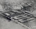
| Date: | 1948 |
|---|---|
| Description: | Aerial view of Waukesha Works, a foundry. |
If you didn't find the material you searched for, our Library Reference Staff can help.
Call our reference desk at 608-264-6535 or email us at: