 Filter: Categories of Wisconsin Historical Images
Filter: Subject of Public utilities
Filter: Subject of human settlements
Filter: Categories of Wisconsin Historical Images
Filter: Subject of Public utilities
Filter: Subject of human settlements
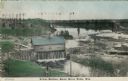
| Date: | 1908 |
|---|---|
| Description: | Colorized photographic postcard of an elevated view of the power station next to the river. A bridge is in the background. Caption reads: "Power Station, B... |
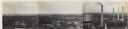
| Date: | 1930 |
|---|---|
| Description: | Panoramic elevated view to the northeast from the Capitol Square. |
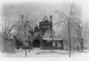
| Date: | 1922 |
|---|---|
| Description: | Trees broken and bowed under the weight of a heavy coating of ice stand in front of the Al. Ringling home. Limbs litter the snow-covered ground. Ice is on ... |
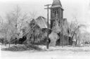
| Date: | 1922 |
|---|---|
| Description: | Downed wires and broken tree limbs mar the scene in front of the First Congregational Church at 131 6th Avenue. |

| Date: | 1888 |
|---|---|
| Description: | This map has relief shown by hachures and features inset maps of a plat of E.D. Clinton and Blackwell’s add’n to the City of La Crosse. Wards (1-10) shaded... |

| Date: | 1894 |
|---|---|
| Description: | This map shows lot and block numbers, railroads, street car tracks, sewers, water mains, gas mains, paved streets, land owned by the Land & River Improveme... |

| Date: | |
|---|---|
| Description: | Outdoor view of men working at a construction site. Identified as the construction of the third powerhouse, which also entailed moving the second powerhous... |

| Date: | 06 30 1965 |
|---|---|
| Description: | Steam pipe construction along Langdon street east of Park street. The corner of the Wisconsin Historical Society is on the left. Science Hall is in the bac... |

| Date: | 01 13 1914 |
|---|---|
| Description: | Smoke billowing from windows on the State Street (left) and Carroll Street (right) sides of the Wisconsin Building. Fire fighters on ladders are working fr... |

| Date: | 01 13 1914 |
|---|---|
| Description: | A policeman, center, keeping an eye on bystanders as firemen on ladders fight a fire at the Wisconsin Building on State Street. The building housed the Com... |

| Date: | 1906 |
|---|---|
| Description: | The printed inscription identifies this scene, "Looking South on Main Street, Montello, Wis." A woman is standing on the sidewalk at left near a parked bug... |
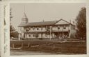
| Date: | 1897 |
|---|---|
| Description: | A cabinet card photograph of the Montello House Hotel. The two-story brick building has a gable fronted wing on the right and a shingled wooden tower on th... |

| Date: | 1973 |
|---|---|
| Description: | This map is 1 of 7 and includes a location map and township diagram in the margins. The map includes a key of land type: Residential (yellow), Commercial (... |

| Date: | 1973 |
|---|---|
| Description: | This map is 2 of 7 and includes a location map and township diagram in the bottom margin. The map includes a key of land type: Residential (yellow), Commer... |

| Date: | 1973 |
|---|---|
| Description: | This map is 3 of 7 and includes a location map and township diagram in the margins. The map includes a key of land type: Residential (yellow), Commercial (... |

| Date: | 1973 |
|---|---|
| Description: | This map is 4 of 7 and includes a location map and township diagram in the left margin. The map includes a key of land type: Residential (yellow), Commerci... |

| Date: | 1973 |
|---|---|
| Description: | This map is 5 of 7 and includes a location map and township diagram in the left margin. The map includes a key of land type: Residential (yellow), Commerci... |

| Date: | 1973 |
|---|---|
| Description: | This map is 6 of 7 and includes a location map and township diagram in the bottom margin. The map includes a key of land type: Residential (yellow), Commer... |

| Date: | 1973 |
|---|---|
| Description: | This map is 7 of 7 and includes a location map and township diagram in the left margin. The map includes a key of land type: Residential (yellow), Commerci... |

| Date: | |
|---|---|
| Description: | View across water towards the shoreline of the eastern isthmus of Madison, including the MG&E power plant smokestacks. A group of people appear to be fishi... |
If you didn't find the material you searched for, our Library Reference Staff can help.
Call our reference desk at 608-264-6535 or email us at: