 Filter: Categories of Wisconsin Historical Images
Filter: Subject of Ponds
Filter: Year of 1800-1899
Filter: Categories of Wisconsin Historical Images
Filter: Subject of Ponds
Filter: Year of 1800-1899

| Date: | 1893 |
|---|---|
| Description: | A cyanotype view of the World's Columbian Exposition grounds from near the North Loop elevated railway station, showing the glass dome of the Horticulture ... |

| Date: | 1893 |
|---|---|
| Description: | A cyanotype view of the Agriculture Building (right) and Manufactures and Liberal Arts Building (left) from the bank of the South Canal at the World's Colu... |

| Date: | 07 23 1898 |
|---|---|
| Description: | Syl stands in front of a pavilion with a well or water pump in a park. A group of adults dressed fashionably stand in the pavilion while drinking water fro... |

| Date: | 08 28 1898 |
|---|---|
| Description: | Syl playing with toy boats at a small pond at Reservoir Park. Other children and adults are around the pond which is on a hill. In the background below the... |

| Date: | 08 28 1898 |
|---|---|
| Description: | Syl playing with other children at reservoir park near a small waterfall. Toy boats are in the pond. |

| Date: | 05 28 1899 |
|---|---|
| Description: | Syl standing in front of a small pond in Reservoir Park. A large group of people is gathered in the background around a tree. |
| Date: | 07 30 1899 |
|---|---|
| Description: | View across pond of Syl at Soldiers Home with aunt Helen standing on a landing near a boat and a flagpole. There is a large group of people gathered around... |
| Date: | 08 28 1898 |
|---|---|
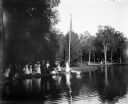
| Description: | A large lily pond at Humboldt Park. Children are playing in the background and the roof of a building is in the distance. |
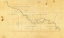
| Date: | 1873 |
|---|---|
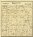
| Description: | Columbia County Atlas Arlington Township 10 North Range 9 East. |

| Date: | 1893 |
|---|---|
| Description: | A view of the World's Columbian Exposition mounted on a cardboard album page, looking east from the Transportation Building. On the right are the Mines Bui... |

| Date: | 1866 |
|---|---|
| Description: | View of earthworks at the battlefield at Resacca. Dirt roads cross the field in the distance, leading to a farm and what appears to be a river. Plate 22... |

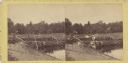
| Date: | 1870 |
|---|---|
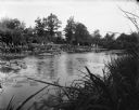
| Description: | View toward the tombstones and a building at Hillside Cemetery and Park. In the foreground is a pond surrounded by vegetation. |

| Date: | 10 1884 |
|---|---|
| Description: | Sanborn insurance map of Black River Falls covering the area bordered by the Black River on the East, 3rd Street on the West, Johnson Street on the North, ... |
| Date: | 1899 |
|---|---|
| Description: | A man steers a horse and carriage down a winding country road near Clarendon Pond. Village dwellings are visible across the pond. |
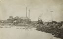
| Date: | 1885 |
|---|---|
| Description: | Photographic postcard view of Weeds Mill. The mill has smokestacks and logs piled on the pond shoreline waiting for processing. A steam locomotive is on th... |
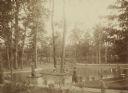
| Date: | 1888 |
|---|---|
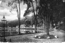
| Description: | Several adults, two children and a dog enjoying a pond at Bracken Brae, the country home of John Johnston (1836-1904), a successful Milwaukee banker. Hilda... |

| Date: | 1883 |
|---|---|
| Description: | This birdseye view map reads: ""MERRILLAN JACKSON COUNTY, WISCONSIN. LOOKING FROM POSITION NORTH EAST ON THE TOWN." At the bottom are points to interest th... |
| Date: | 07 1863 |
|---|---|
| Description: | Stereograph of McPherson's Woods, where General John Reynolds, commanding the First Corps of which Wisconsin's 2nd, 6th, and 7th regiments were a part, was... |
| Date: | 1850 |
|---|---|
| Description: | The map is ink on tracing cloth. The map shows portions of township 20 north, range 12 east, section 30 (in the Town of Saxeville) and township 20 north, r... |

| Date: | 1890 |
|---|---|
| Description: | 90,000 feet of pine logs floating in the storage/sorting pond at the Arpin Lumber Company sawmill. The sawmill and other buildings are in the background. O... |
If you didn't find the material you searched for, our Library Reference Staff can help.
Call our reference desk at 608-264-6535 or email us at: