 Filter: Categories of Wisconsin Historical Images
Filter: Subject of Periodicals
Filter: Subject of trees
Filter: Categories of Wisconsin Historical Images
Filter: Subject of Periodicals
Filter: Subject of trees
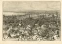
| Date: | 1882 |
|---|---|
| Description: | Bird's-eye view of Milwaukee looking south down 8th Street from Schlitz's Park. |
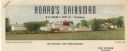
| Date: | |
|---|---|
| Description: | Letterhead of Hoard's Dairyman, the "national dairy farm magazine" published by former governor and proponent of the Wisconsin dairy industry, William Demp... |
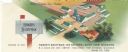
| Date: | |
|---|---|
| Description: | Letterhead of Hoard's Dairyman, "The National Dairy Farm Magazine," with a bird's eye view of the company farm buildings, and a mailbox with an upraised fl... |

| Date: | 05 01 1957 |
|---|---|
| Description: | A volunteer discussing seed catalogs with two nursing home residents as they are sitting outside on lawn chairs. They are at Monona Drive Rest Home at 4202... |

| Date: | 01 22 1944 |
|---|---|
| Description: | A soldier, Sergeant Robert Witzlsteiner of Milwaukee, Wisconsin, reads TIME magazine with his very muddy boots propped on a box. His rifle is across... |

| Date: | |
|---|---|
| Description: | Front porch at Modern Home Hotel. There is a drinking fountain in the foreground on the left. The furniture on the porch includes a desk, rocking chairs, a... |
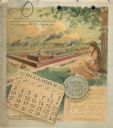
| Date: | 1893 |
|---|---|
| Description: | Calendar back, with the month of December. Features an illustration of the Buckeye Binders and Mowers Factory buildings. In the foreground on the right a y... |

| Date: | 1758 |
|---|---|
| Description: | Map showing lakes, rivers, cities, Native American land, and the boundaries of French and English claims in America and Canada north of New York. A title c... |

| Date: | 1776 |
|---|---|
| Description: | Map of the American colonies and land east of the Mississippi River. Prominent cities, forts, Native American land, mountains, rivers and lakes are all sho... |

| Date: | 1755 |
|---|---|
| Description: | Map of New England, with three inset maps of Fort Oswego, Fort du Quesne, and Fort Frederick. It shows colonies, a few cities, forts (marked as French or E... |

| Date: | 1760 |
|---|---|
| Description: | Map showing the towns, mountains, valleys, corn fields, and rivers of a portion of the Cherokee Nation. A few annotations on the map explain the land and r... |
If you didn't find the material you searched for, our Library Reference Staff can help.
Call our reference desk at 608-264-6535 or email us at: