 Filter: Categories of Wisconsin Historical Images
Filter: Subject of Periodicals
Filter: Subject of periodicals
Filter: Subject of land use
Filter: Categories of Wisconsin Historical Images
Filter: Subject of Periodicals
Filter: Subject of periodicals
Filter: Subject of land use

| Date: | 1969 |
|---|---|
| Description: | A woman stands behind the counter under an awning of a newspaper stand. |

| Date: | 1969 |
|---|---|
| Description: | On the left is part of a "New York State Lottery" sign, and on the right, a number of magazines are displayed, probably part of a newspaper stand. |

| Date: | 11 06 1948 |
|---|---|
| Description: | Featured in a Harry S. Manchesters window titled "Dreamland," 2 East Mifflin Street, is a painting of a farm near Madison by John Atherton for The Satur... |

| Date: | 06 10 1952 |
|---|---|
| Description: | Grandfather Harry L. Geisler reads a Woman's Day magazine to his grandchildren, Timmy (James William), 5, and Nancy Anne, 2, at their home at 3120 Oxford R... |
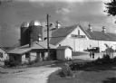
| Date: | |
|---|---|
| Description: | A model dairy farm maintained by Hoard's "Dairyman Magazine" for experimental purposes. Two women are walking in the driveway near the buildings on the rig... |
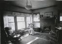
| Date: | 1931 |
|---|---|
| Description: | Miss Lielle Geddis sitting in a rocking chair while reading an issue of "Country Gentleman" magazine in the living room of her home. |
| Date: | |
|---|---|
| Description: | Letterhead of Hoard's Dairyman, the "national dairy farm magazine" published by former governor and proponent of the Wisconsin dairy industry, William Demp... |

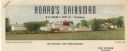
| Date: | |
|---|---|
| Description: | Letterhead of Hoard's Dairyman, "The National Dairy Farm Magazine," with a bird's eye view of the company farm buildings, and a mailbox with an upraised fl... |

| Date: | 1775 |
|---|---|
| Description: | Map of Boston and surrounding regions, from Massachusetts Bay to the Connecticut River, and including part of southern New Hampshire. It shows the colonies... |

| Date: | 1762 |
|---|---|
| Description: | Map of Virginia and parts of Maryland. It shows borders, boundary lines, Native American tribes and land, towns, forts, roads, mountains, waterfalls, bays,... |

| Date: | 1760 |
|---|---|
| Description: | Map showing the towns, mountains, valleys, corn fields, and rivers of a portion of the Cherokee Nation. A few annotations on the map explain the land and r... |
If you didn't find the material you searched for, our Library Reference Staff can help.
Call our reference desk at 608-264-6535 or email us at: