 Filter: Categories of Wisconsin Historical Images
Filter: Subject of Periodicals
Filter: Creator Name of Unknown
Filter: Subject of arts
Filter: Categories of Wisconsin Historical Images
Filter: Subject of Periodicals
Filter: Creator Name of Unknown
Filter: Subject of arts

| Date: | 12 13 1917 |
|---|---|
| Description: | A color cartoon depicting Robert M. La Follette, Sr. as pro-German, showing Kaiser pinning medals on him. |

| Date: | 03 24 1969 |
|---|---|
| Description: | Young woman at work designing a magazine cover. |
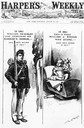
| Date: | 08 29 1896 |
|---|---|
| Description: | Cover of Harper's Weekly, with a pro-William McKinley Presidential cartoon depicting McKinley as a soldier in 1861 and William Jennings Bryan as an ... |

| Date: | 08 1937 |
|---|---|
| Description: | Cover of The American Dancer magazine featuring Leo Kehl, head of the Kehl School of Dance and Genevieve Esse Kehl. |
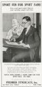
| Date: | 1921 |
|---|---|
| Description: | Advertisement entitled "Sport Fun For Sport Fans!". It includes a photograph of comic artist Jay Orving and the character Bozo Blimp. |

| Date: | 04 19 1942 |
|---|---|
| Description: | Magazine clipping featuring Ronald Reagan in his army uniform prior to reporting for active duty in 1942. |

| Date: | |
|---|---|
| Description: | Magazine clipping featuring Ronald Reagan as the host of G.E. True Theatre. |

| Date: | 1763 |
|---|---|
| Description: | Map of America and part of Canada including the borders of European claims after the French and Indian War. Cities, forts, Native American lands, rivers, l... |

| Date: | 1776 |
|---|---|
| Description: | Map of the American colonies and land east of the Mississippi River. Prominent cities, forts, Native American land, mountains, rivers and lakes are all sho... |

| Date: | 1755 |
|---|---|
| Description: | Map of New England, with three inset maps of Fort Oswego, Fort du Quesne, and Fort Frederick. It shows colonies, a few cities, forts (marked as French or E... |

| Date: | 1775 |
|---|---|
| Description: | Map of Boston and surrounding regions, from Massachusetts Bay to the Connecticut River, and including part of southern New Hampshire. It shows the colonies... |

| Date: | 1675 |
|---|---|
| Description: | Map of the southeast coast of North America from Jamestown to modern Georgia. It shows European settlements, Native American land and villages, coastal fea... |

| Date: | 1936 |
|---|---|
| Description: | Reprint of caricatures from various publications. There are eight panels depicting the Spanish Civil War from publications such as "L'Œuvre," "El Noticiero... |

| Date: | 1936 |
|---|---|
| Description: | "La caricatura y la guerra. Graphic supplement to the «Servicio Español de Información»." Reprint of caricatures from various publications. There are seve... |
If you didn't find the material you searched for, our Library Reference Staff can help.
Call our reference desk at 608-264-6535 or email us at: