 Filter: Categories of Wisconsin Historical Images
Filter: Subject of Parks
Filter: Year of 1800-1899
Filter: Subject of water
Filter: Categories of Wisconsin Historical Images
Filter: Subject of Parks
Filter: Year of 1800-1899
Filter: Subject of water

| Date: | 1890 |
|---|---|
| Description: | Bird's-eye map of Ashland, viewed from Lake Superior, with insets of Prentice Park and Fishery. Population 16,000. Increase in Ten Years, 11,000. |

| Date: | 1882 |
|---|---|
| Description: | Bird's-eye map of Lake Geneva, looking southwest, with insets of points of interest. |

| Date: | 1891 |
|---|---|
| Description: | Bird's-eye view of Eau Claire. |
| Date: | 1873 |
|---|---|
| Description: | Elevated view of South Pinckney Street from the Wisconsin State Capitol, with East Washington Avenue to the left and Lake Monona on the distant right. The ... |
| Date: | 1860 |
|---|---|
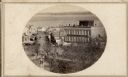
| Description: | Intersection of King and East Main streets photographed by John S. Fuller from the Wisconsin State Capitol roof, about 1860-1863. In the foreground two st... |

| Date: | 1896 |
|---|---|
| Description: | A portion of John B. Heim's map of the Water Works System of Madison showing the size of the third Wisconsin Capitol (228' x 226') in comparison with the C... |

| Date: | 1892 |
|---|---|
| Description: | Bird's-eye view of Chicago, with ships in the Lake Michigan harbor. |

| Date: | 1876 |
|---|---|
| Description: | "View of the Capitol, with all the Flags" one of four "Different Views of Parades in the Streets" identified in Dahl's 1877 "Catalogue of Stereoscopic View... |

| Date: | 1876 |
|---|---|
| Description: | Three men on shoreline of Lake Mendota, one wearing a military uniform like those worn during the 1876 Centennial Celebrations in Madison. The location app... |
| Date: | 1885 |
|---|---|
| Description: | Chippewa Falls with a park and river in the foreground. |
| Date: | 1870 |
|---|---|
| Description: | View across water towards the Habheger's Bowling Park at the North Fourth Street bridge. A group of people are standing on the bridge. |
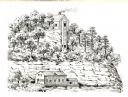
| Date: | 1836 |
|---|---|
| Description: | The shot tower at Tower Hill State Park. |
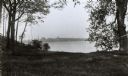
| Date: | 1894 |
|---|---|
| Description: | A view from Pleasure Park. The Wisconsin State Capitol is seen across the lake and is framed by two trees in the foreground. |

| Date: | 1883 |
|---|---|
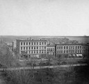
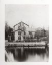
| Description: | Caption on reverse side of stereograph reads, "Governmental buildings, Wisconsin Conservatory of Music and Hospital over Lake Mendota-looking from Capitol ... |
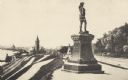
| Date: | 1895 |
|---|---|
| Description: | Side view of the statue on a plinth with Celtic designs, with his right hand holding a horn resting on his hip. The statue is located in Juneau Park. On th... |
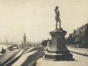
| Date: | 1893 |
|---|---|
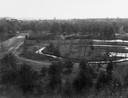
| Description: | Statue of Leif Ericson is to the right of center in the foreground, with the figure facing the city. On the left is a hill with paths, a train station, ra... |
| Date: | 1870 |
|---|---|
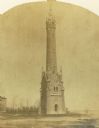
| Description: | Water tower of the Milwaukee water works, North Point. |
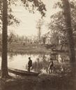
| Date: | 1870 |
|---|---|
| Description: | Two men are in the foreground on a shoreline, one standing in a boat. In the background on the other shoreline are adults and children sitting in the gras... |
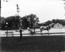
| Date: | 1899 |
|---|---|
| Description: | A male grounds keeper is driving a horse-drawn mower down a path on a park or estate grounds. Another man is leaning against a slender tree. Both men are w... |
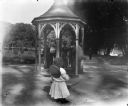
| Date: | 07 23 1898 |
|---|---|
| Description: | Syl stands in front of a pavilion with a well or water pump in a park. A group of adults dressed fashionably stand in the pavilion while drinking water fro... |
If you didn't find the material you searched for, our Library Reference Staff can help.
Call our reference desk at 608-264-6535 or email us at: