 Filter: Categories of Wisconsin Historical Images
Filter: Subject of Oneida Indians
Filter: Subject of oneida indians
Filter: Subject of cities and towns
Filter: Categories of Wisconsin Historical Images
Filter: Subject of Oneida Indians
Filter: Subject of oneida indians
Filter: Subject of cities and towns
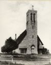
| Date: | 1900 |
|---|---|
| Description: | Hobart Episcopal Church on the Oneida Indian Reservation. |
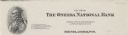
| Date: | |
|---|---|
| Description: | Numbered memohead of the Oneida National Bank of Rhinelander, Wisconsin, with a profile view of a Native American man wearing beads, feathers, a ribbon in ... |

| Date: | 1846 |
|---|---|
| Description: | A map of Wisconsin and a portion of Minnesota that show the township surveys in progress in portions of the Saint Croix River region and in central Wiscons... |

| Date: | 1857 |
|---|---|
| Description: | A map of the state of Wisconsin and the southeastern portion of the Territory of Minnesota, showing the Wisconsin reservations of the Oneida, Menominee, St... |

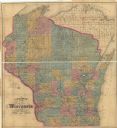
| Date: | 1860 |
|---|---|
| Description: | A map of Wisconsin showing the railroads, rivers, counties, cities, villages, and named towns in the state, as well as the township grid for the portion of... |

| Date: | 1856 |
|---|---|
| Description: | This map with an ornamental border shows the township survey grid and identifies counties, named towns, cities and villages, rivers, lakes, railroads, road... |

| Date: | 1856 |
|---|---|
| Description: | This map of shows the township survey grid and identifies counties, named towns, cities and villages, rivers, lakes, railroads, roads, and the Menomonee an... |

| Date: | 1857 |
|---|---|
| Description: | This map depicts the township survey grid and identifies counties, named towns, cities and villages, rivers, lakes, railroads, roads, and the Menomonee and... |

| Date: | 1858 |
|---|---|
| Description: | This map of the entire state of Wisconsin depicts the township survey grid and identifies counties, named towns, cities and villages, rivers, lakes, railro... |

| Date: | 1859 |
|---|---|
| Description: | This map of the entire state of Wisconsin depicts the township survey grid and identifies counties, named towns, cities and villages, rivers, lakes, railro... |

| Date: | 1864 |
|---|---|
| Description: | This map of the entire state of Wisconsin depicts the township survey grid and identifies counties, named towns, cities and villages, rivers, lakes, railro... |

| Date: | 1865 |
|---|---|
| Description: | This map of the entire state of Wisconsin depicts the township survey grid and identifies counties, named towns, cities and villages, rivers, lakes, railro... |

| Date: | 1867 |
|---|---|
| Description: | A hand-colored map of Wisconsin showing the state’s township grid, lakes, rivers, railroads, as well as the locations of towns, counties and the reservatio... |

| Date: | 1871 |
|---|---|
| Description: | This map of Wisconsin and surrounding states depicts the township survey grid and identifies counties, named towns, cities and villages, rivers, lakes, rai... |

| Date: | 1871 |
|---|---|
| Description: | This map of Wisconsin and surrounding states depicts the township survey grid and identifies counties, named towns, cities and villages, rivers, lakes, rai... |
| Date: | 1872 |
|---|---|
| Description: | This map of Wisconsin depicts the township survey grid and identifies counties, named towns, cities and villages, rivers, lakes, railroads, and the Chippew... |

| Date: | 1874 |
|---|---|
| Description: | This hand-colored map shows the railroads "completed" "in progress" and "contemplated" rivers, counties, cities and villages, and named towns in the state,... |

| Date: | 1873 |
|---|---|
| Description: | This hand-colored map of Wisconsin depicts the township survey grid and identifies counties, named towns, cities and villages, rivers, lakes, railroads, an... |

| Date: | 1875 |
|---|---|
| Description: | This hand-colored map of Wisconsin and the western portion of Michigan's Upper Peninsula depicts the township survey grid and identifies counties, named to... |

| Date: | 1902 |
|---|---|
| Description: | This map shows the railroads of southern Wisconsin with the routes of the Chicago, Milwaukee, and St. Paul Railway traced in red. The township grid, counti... |
If you didn't find the material you searched for, our Library Reference Staff can help.
Call our reference desk at 608-264-6535 or email us at: