 Filter: Categories of Wisconsin Historical Images
Filter: Subject of Ocean
Filter: Subject of shorelines
Filter: Subject of islands
Filter: Categories of Wisconsin Historical Images
Filter: Subject of Ocean
Filter: Subject of shorelines
Filter: Subject of islands

| Date: | 04 1971 |
|---|---|
| Description: | Poster featuring a stylized sun rising over the ocean, advertising spring break vacations to Nassau for University of Wisconsin faculty and students. |
| Date: | |
|---|---|
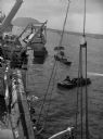
| Description: | Wounded soldiers are being loaded onto a hospital ship in Iwo Jima. |

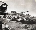
| Date: | 1945 |
|---|---|
| Description: | Marines use an International TD-9 crawler tractor (TracTracTor) and dozer shovel loader to unload supplies on a beach. A ship is in the background. The ori... |

| Date: | 1945 |
|---|---|
| Description: | Marines use an International TD-9 crawler tractor (TracTracTor) with a dozer shovel loader to fill a truck parked on a beach. A ship is in the water behind... |
| Date: | 1945 |
|---|---|
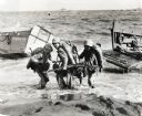
| Description: | Three marines dressed in uniform, carrying packs and holding guns, pull an ammunition cart through the water towards the beach at Iwo Jima. Military boats ... |
| Date: | 1945 |
|---|---|
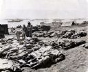
| Description: | Marines, killed in action, lie on stretchers covered with ponchos on the beach at Iwo Jima. Four marines attend to the dead. Tents, military boats, and an ... |
| Date: | 02 19 1945 |
|---|---|
| Description: | Marines on the beach and military boats, including an LSM 242, in the water at Iwo Jima. |
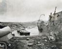
| Date: | 1945 |
|---|---|
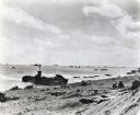
| Description: | Parts of destroyed boats and military equipment on the shoreline of Iwo Jima on D-Day. |
| Date: | 1945 |
|---|---|
| Description: | Marines dig foxholes into the sand on the beaches of Iwo Jima. The men are surrounded by military equipment, including a crane. An International Diesel cra... |
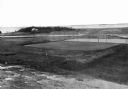
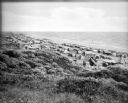
| Date: | |
|---|---|
| Description: | Elevated view of golf links featuring Squaw Island in the distance. |

| Date: | |
|---|---|
| Description: | Hand-drawn map of the area at the time of Pilgrim landing, drawn by Charles Blaskowikz. Includes commemorative historical notes. |
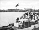
| Date: | |
|---|---|
| Description: | Slightly elevated view of a crowd of people standing on boats lined up along a pier to watch a bi-winged airplane flying over the water. Large buildings ar... |
| Date: | |
|---|---|
| Description: | Tents line a beach along the Atlantic Ocean. Foliage covers the foreground and several people and vehicles can be seen throughout the camp. |

| Date: | 1959 |
|---|---|
| Description: | Aerial view of the island of Cuba taken from a small plane. Part of the plane with a Cuban flag painted on it is in the frame, and the island with many bui... |
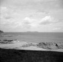
| Date: | 08 31 1944 |
|---|---|
| Description: | View from shoreline of Cezembre Island, just north of Saint-Malo on the north coast of France. It was German-occupied until the Allies mounted an operation... |

| Date: | 02 20 1945 |
|---|---|
| Description: | The caption in the Milwaukee Journal, says it best, "From the far-off Pacific (somewhere on Kwajalein), the picture of Ensign Ray Hanson and Robert ... |

| Date: | 07 21 1925 |
|---|---|
| Description: | Dinner menu from the Hotel St. Catherine, with a color postcard at the top, meant to be detached and mailed, with a view of the hotel against a backdrop of... |

| Date: | |
|---|---|
| Description: | Letterhead of Johnson & Melaas, merchant tailors and cloth dealers, "Buyers of wool and Wisconsin leaf tobacco," with an engraving of a waterfront view of ... |

| Date: | 1786 |
|---|---|
| Description: | One half of a four sheet nautical chart, showing the coastlines of the north-west hemisphere. The interior lands are left bare, even of basic features such... |

| Date: | 1780 |
|---|---|
| Description: | This map shows the townships, parishes, cities, towns, plantations, lakes, rivers, swamps, and roads near the coast of South Carolina and Georgia. Emphasis... |
If you didn't find the material you searched for, our Library Reference Staff can help.
Call our reference desk at 608-264-6535 or email us at: