 Filter: Categories of Wisconsin Historical Images
Filter: Subject of Ocean
Filter: Subject of shorelines
Filter: Subject of intellectual life
Filter: Categories of Wisconsin Historical Images
Filter: Subject of Ocean
Filter: Subject of shorelines
Filter: Subject of intellectual life

| Date: | 1939 |
|---|---|
| Description: | Aerial view of International Harvester's Geelong Works in Geelong, Victoria, Australia. |

| Date: | |
|---|---|
| Description: | Hand-drawn map of the area at the time of Pilgrim landing, drawn by Charles Blaskowikz. Includes commemorative historical notes. |
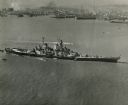
| Date: | 10 23 1945 |
|---|---|
| Description: | Aerial view of U.S.S. Wisconsin (BB-64) in San Francisco Bay. Several boats can be seen in the water near the ship and San Francisco is visible in t... |

| Date: | 1959 |
|---|---|
| Description: | Aerial view of the island of Cuba taken from a small plane. Part of the plane with a Cuban flag painted on it is in the frame, and the island with many bui... |

| Date: | 1945 |
|---|---|
| Description: | Leota Kelly, director of the Red Cross's Pacific Athletic Club, posing for a picture by the shore in Tinian at the site of the new Red Cross Club. Kelly is... |

| Date: | 07 21 1925 |
|---|---|
| Description: | Dinner menu from the Hotel St. Catherine, with a color postcard at the top, meant to be detached and mailed, with a view of the hotel against a backdrop of... |
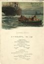
| Date: | 09 17 1908 |
|---|---|
| Description: | Dinner menu for the S.S. Marquette, with people in a rowboat near a larger ship, with windmills in the distance on shore. The image is signed "Heuss... |

| Date: | |
|---|---|
| Description: | Letterhead of Johnson & Melaas, merchant tailors and cloth dealers, "Buyers of wool and Wisconsin leaf tobacco," with an engraving of a waterfront view of ... |

| Date: | 1920 |
|---|---|
| Description: | Aerial view looking over railroad cars on railroad tracks towards an encampment. Signs on a building at the encampment read: "War Exposition," and "Three M... |

| Date: | 1920 |
|---|---|
| Description: | Aerial view looking over railroad cars on railroad tracks towards an encampment. Signs on a building at the encampment read: "War Exposition," and "Three M... |

| Date: | 1786 |
|---|---|
| Description: | One half of a four sheet nautical chart, showing the coastlines of the north-west hemisphere. The interior lands are left bare, even of basic features such... |

| Date: | 1780 |
|---|---|
| Description: | This map shows the townships, parishes, cities, towns, plantations, lakes, rivers, swamps, and roads near the coast of South Carolina and Georgia. Emphasis... |

| Date: | 1918 |
|---|---|
| Description: | Poster with an illustration of Uncle Sam arm-in-arm with Britannia. Uncle Sam has a sword, and Britannia holds a shield with the Union Jack and a triton. A... |
If you didn't find the material you searched for, our Library Reference Staff can help.
Call our reference desk at 608-264-6535 or email us at: