 Filter: Categories of Wisconsin Historical Images
Filter: Subject of Ocean
Filter: Subject of persons
Filter: Subject of mountains
Filter: Categories of Wisconsin Historical Images
Filter: Subject of Ocean
Filter: Subject of persons
Filter: Subject of mountains
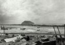
| Date: | 02 1945 |
|---|---|
| Description: | Airfield #1, Iwo Jima, with Mt Surabachi in the distance. This image is one of many taken by Milwaukee photographer Dickey Chapelle during the assault on ... |

| Date: | 1893 |
|---|---|
| Description: | Front and back covers of an advertising brochure for the New Empire line of mowers, reapers and grain binders manufactured by J.F. Seiberling & Company. Th... |

| Date: | 1934 |
|---|---|
| Description: | An original lithograph promoting California as a summer's destination to be reached by train. The poster features a woman in a vibrant yellow dress overloo... |

| Date: | |
|---|---|
| Description: | Women loading cargo onto a U.S. ship at St. Thomas in the Virgin Islands by way of baskets balanced on the tops of their heads. |
| Date: | |
|---|---|
| Description: | Elevated view of an Eskimo tent village on sandspit along the shoreline. Wood buildings are along higher ground on the right near a river. |
| Date: | 08 11 1943 |
|---|---|
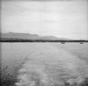
| Description: | A view of Milne Bay, New Guinea (present day Papua New Guinea), from the sea. A ship can be seen on the right, at the shoreline. |

| Date: | 08 11 1943 |
|---|---|
| Description: | Crew of four aboard a Higgins boat, also known as a LCVP, which stands for "Landing Craft, Vehicle, Personnel." Their names, left to right, are Fireman 1st... |
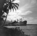
| Date: | 10 26 1943 |
|---|---|
| Description: | A warship moored at the Island Jetty Dock on Goodenough Island, in the Solomon Sea, New Guinea (present day Papua New Guinea). A palm tree is silhouetted o... |
| Date: | 12 26 1943 |
|---|---|
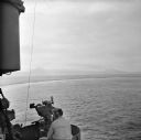
| Description: | Elevated view from aboard ship looking down on a soldier in a turret operating a range finder. These warships were participating in the heavy bombardment o... |

| Date: | 12 26 1943 |
|---|---|
| Description: | Navigation instruments on an American cruiser were checked by Lieutenant Commander Leonard Meyer of Appleton. Three other crew members are nearby. The crui... |

| Date: | 12 26 1943 |
|---|---|
| Description: | Elevated view looking down towards deck of an American cruiser leaving the base heading for the bombardment of Cape Gloucester, New Britain, New Guinea (pr... |

| Date: | 12 26 1943 |
|---|---|
| Description: | Elevated view, perhaps from an American Cruiser, of warships leaving the base heading for the bombardment of Cape Gloucester, New Britain, New Guinea (pres... |

| Date: | 12 26 1943 |
|---|---|
| Description: | Seaman 2nd Class Jerry Burg (left) of Milwaukee, Wisconsin, and Seaman 2nd Class Harold Dawson of Toledo, Ohio, man the plane spotting station on an Americ... |
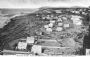
| Date: | 01 02 1944 |
|---|---|
| Description: | Robert Doyle's caption that ran with this photograph: "Here is a general view of the beachhead at Saidor seized by the Red Arrow task force. Several ships ... |

| Date: | 1927 |
|---|---|
| Description: | A switchback path leading to Cap Carbon and the lighthouse perched near the summit of the peninsula. The lighthouse is built on top of a giant rock that pr... |

| Date: | 1696 |
|---|---|
| Description: | Engraved and hand-colored map of Ethiopia, from Blaeu's General Atlas. Map title is framed by a man and a woman, both wearing head turbans, who are standin... |

| Date: | |
|---|---|
| Description: | Front cover and partial menu listing with drinks overleaf. Front cover has a porthole view of pairs of men in three boats with mountains and palm trees in ... |

| Date: | 1893 |
|---|---|
| Description: | Calendar front, with the month of January, 1893. At the top it reads: "1893 calendar presented to the farmers of the world with the compliments of Aultman,... |

| Date: | 1746 |
|---|---|
| Description: | Map of North America from the southern portion of James Bay to Florida. It shows the colonies, cities, Native American land, and topological and geographic... |

| Date: | 1627 |
|---|---|
| Description: | Map of North and South America showing settlements, rivers, lakes, mountains, islands and regions of the western hemisphere. It includes an inset map of Gr... |
If you didn't find the material you searched for, our Library Reference Staff can help.
Call our reference desk at 608-264-6535 or email us at: