 Filter: Categories of Wisconsin Historical Images
Filter: Subject of Ocean
Filter: Subject of military bases
Filter: Categories of Wisconsin Historical Images
Filter: Subject of Ocean
Filter: Subject of military bases
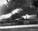
| Date: | 12 07 1941 |
|---|---|
| Description: | The USS Nevada in berth at Pearl Harbor with the USS Shaw burning in the background after its forward deck was hit with a Japanese bomb. |
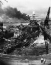
| Date: | 12 07 1941 |
|---|---|
| Description: | The remains of the USS Cassin and the USS Downes floating in front of the USS Pennsylvania in dock at Pearl Harbor. On the left is th... |
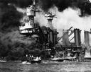
| Date: | 12 07 1941 |
|---|---|
| Description: | Sailors in a motor launch attempt a rescue of survivors from the water alongside the sunken battleship USS West Virginia during or shortly after the... |
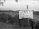
| Date: | 1942 |
|---|---|
| Description: | A soldier walks along the edge of a cliff in Panama, behind stacks of cannonballs and a large sign. The man is wearing a uniform and is holding a sub-machi... |

| Date: | 07 1941 |
|---|---|
| Description: | Advertising proof for International trucks, featuring color illustrations of a truck and the United States, largely in red, white and blue. Includes the te... |
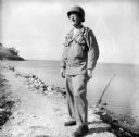
| Date: | 12 18 1943 |
|---|---|
| Description: | Robert Doyle's caption that accompanied this image reads, "Lieutenant Colonel Philip F. La Follette, three times Governor of Wisconsin, poses in combat uni... |

| Date: | 02 05 1944 |
|---|---|
| Description: | General view of Port Moresby Harbor from road, New Guinea (present day Papua New Guinea). A jeep is on the road on the left. Several soldiers are near a sh... |
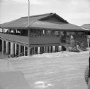
| Date: | 02 05 1944 |
|---|---|
| Description: | View from road of the exterior of the Allied Officers' Club in Port Moresby, New Guinea (present day Papua New Guinea). It is built on posts above the wate... |

| Date: | 1781 |
|---|---|
| Description: | Map of the Southeastern part of the British Colonies in North America, Gulf Coast and Caribbean. It illustrates the of the Spanish and English fleets, part... |
If you didn't find the material you searched for, our Library Reference Staff can help.
Call our reference desk at 608-264-6535 or email us at: