 Filter: Categories of Wisconsin Historical Images
Filter: Subject of Ocean
Filter: Subject of military art and science
Filter: Subject of arts
Filter: Categories of Wisconsin Historical Images
Filter: Subject of Ocean
Filter: Subject of military art and science
Filter: Subject of arts
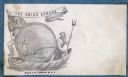
| Date: | 1860 |
|---|---|
| Description: | A Union sailor and King Neptune stand inside a sea shell that is floating on the ocean. Between them appears a decorative circle with the Union Armada in i... |
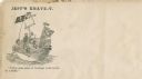
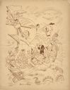
| Date: | 1860 |
|---|---|
| Description: | Jefferson Davis and six sailors sail in a tea cup. A pirate flag flies overhead. One sailor is in the "crow's nest." Another is using a paddle. Three sailo... |
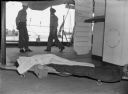
| Date: | 1945 |
|---|---|
| Description: | A body on a stretcher is lying on the deck of the USS "Samaritan." The body is covered by a blanket, except for an arm which has a small tattoo. Behind the... |
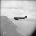
| Date: | 08 25 1944 |
|---|---|
| Description: | Aerial view over wing of formation of Douglas C-47 Skytrain cargo and troop transport planes leaves Saidor, New Guinea (present day Papua New Guinea). Robe... |
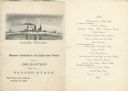
| Date: | 11 26 1898 |
|---|---|
| Description: | Menu for a "Banquet tendered by the Union Iron Works to the Delegation from the Badger State" given at the Palace Hotel, with an etching of the Battleship ... |
| Date: | 02 02 1951 |
|---|---|
| Description: | Front cover of the menu and program for the Fifth Anniversary of the Secretary-Generalship of Trygve Lie, first Secretary-General of the United Nations (UN... |

| Date: | 1740 |
|---|---|
| Description: | Engraved and hand-colored map of the Iberian peninsula as a theater of war during the War of the Spanish Succession (1701-1714). The map is dedicated to Ki... |
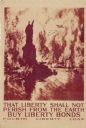
| Date: | 1918 |
|---|---|
| Description: | United States government bonds poster in the Fourth Liberty Loan "B" series. "Buy Liberty Bonds. Fourth Liberty Loan." Depicts enemy aircraft bombing New Y... |

| Date: | 1920 |
|---|---|
| Description: | Aerial view looking over railroad cars on railroad tracks towards an encampment. Signs on a building at the encampment read: "War Exposition," and "Three M... |

| Date: | 1746 |
|---|---|
| Description: | A map of the western hemisphere, including parts of western Europe and Africa, showing the division of the Americas by the European powers. Weapons and fol... |

| Date: | 1733 |
|---|---|
| Description: | This map of North America shows settlements, rivers, lakes, Native American land, trade winds, and numerous topographical features such as forests and moun... |

| Date: | 1770 |
|---|---|
| Description: | Map of North America from the Great Lakes to the northern portion of South America. It shows cities, Native American land, mountains, swamps, lakes, rivers... |

| Date: | 1781 |
|---|---|
| Description: | Map of the Southeastern part of the British Colonies in North America, Gulf Coast and Caribbean. It illustrates the of the Spanish and English fleets, part... |

| Date: | 1920 |
|---|---|
| Description: | Stone lanterns on the shore near a leaning pine tree frame a view of the Great Torii on Japan's Inland Sea. Two Japanese women in traditional kimonos are s... |
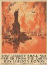
| Date: | 1918 |
|---|---|
| Description: | Poster depicting enemy aircraft bombing New York, which is in flames. In the foreground, the Statue of Liberty has been attacked and its head has been seve... |
If you didn't find the material you searched for, our Library Reference Staff can help.
Call our reference desk at 608-264-6535 or email us at: