 Filter: Categories of Wisconsin Historical Images
Filter: Subject of Ocean
Filter: Subject of flowers
Filter: Categories of Wisconsin Historical Images
Filter: Subject of Ocean
Filter: Subject of flowers
| Date: | |
|---|---|
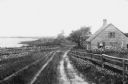
| Description: | View of a cottage separated from Oyster Pond by fences and an unpaved road. |

| Date: | 1780 |
|---|---|
| Description: | This map portrays North and South America at a very unusual angle, with north oriented towards the upper right corner. Colonies, Native American land, a fe... |

| Date: | 1759 |
|---|---|
| Description: | Map of North and South America showing regions, colonies, cities and settlements, rivers, lakes, and Native American land. Near the bottom left an inset ma... |

| Date: | 1952 |
|---|---|
| Description: | Typewritten note on Royal Hawaiian stationery reads: "Royal Hawaiian, Honolulu, Hawaii, U.S.A. Esther Van Wagoner Tufty, Washington D.C. war correspondent ... |
If you didn't find the material you searched for, our Library Reference Staff can help.
Call our reference desk at 608-264-6535 or email us at: