 Filter: Categories of Wisconsin Historical Images
Filter: Subject of Ocean
Filter: Subject of cities and towns
Filter: Subject of shorelines
Filter: Categories of Wisconsin Historical Images
Filter: Subject of Ocean
Filter: Subject of cities and towns
Filter: Subject of shorelines

| Date: | 1939 |
|---|---|
| Description: | Aerial view of International Harvester's Geelong Works in Geelong, Victoria, Australia. |

| Date: | |
|---|---|
| Description: | Panoramic collotype of Havana, Cuba harbor. Numerous boats are visible. Sky appears to have been masked out before printing. |

| Date: | |
|---|---|
| Description: | Bloch on a ship in Mississippi at New Orleans, headed for Baton Rouge. Trip was gratis from Victor Ehr, director of the Baton Rouge chamber of commerce and... |
| Date: | 1920 |
|---|---|
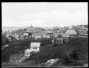
| Description: | Elevated view from hill looking down toward buildings in the hills along the coast. |

| Date: | |
|---|---|
| Description: | View across water toward people on a small sailboat on Barnegat Bay, and boathouses and buildings on the far shoreline. |

| Date: | |
|---|---|
| Description: | Elevated view of village homes on the shores of the bay with docked fishing boats in the foreground. Caption reads, "Marblehead, Mass from Rockmere Point." |

| Date: | |
|---|---|
| Description: | View of Plymouth Street looking towards the waterfront with large trees along the sidewalks. |

| Date: | |
|---|---|
| Description: | View of the "Russell 5" tugboat in the water near New York City. An American flag is flying on the boat. "Russell 5" is painted on the vessel. The shorelin... |

| Date: | 1968 |
|---|---|
| Description: | A man walking with a cane in the sand dunes on Coney Island. A dilapidated fence cuts across the foreground of the beach and a rock jetty juts into the ba... |
| Date: | 10 23 1945 |
|---|---|
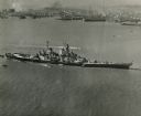
| Description: | Aerial view of U.S.S. Wisconsin (BB-64) in San Francisco Bay. Several boats can be seen in the water near the ship and San Francisco is visible in t... |
| Date: | 1910 |
|---|---|
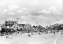
| Description: | View along beach toward sunbathers sitting and walking along the seashore. A line of automobiles are parked alongside the beach, separated from the sand by... |

| Date: | 1959 |
|---|---|
| Description: | Aerial view of the island of Cuba taken from a small plane. Part of the plane with a Cuban flag painted on it is in the frame, and the island with many bui... |
| Date: | |
|---|---|
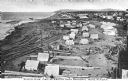
| Description: | Elevated view of an Eskimo tent village on sandspit along the shoreline. Wood buildings are along higher ground on the right near a river. |

| Date: | 1862 |
|---|---|
| Description: | This map of the southeastern United States shows forts and battlefields, railroads, rivers, and cities and towns. Dates of admission and secession of the s... |

| Date: | 02 05 1944 |
|---|---|
| Description: | General view of Port Moresby Harbor from road, New Guinea (present day Papua New Guinea). A jeep is on the road on the left. Several soldiers are near a sh... |

| Date: | 1893 |
|---|---|
| Description: | Calendar front, with the month of January, 1893. At the top it reads: "1893 calendar presented to the farmers of the world with the compliments of Aultman,... |

| Date: | |
|---|---|
| Description: | Letterhead of Johnson & Melaas, merchant tailors and cloth dealers, "Buyers of wool and Wisconsin leaf tobacco," with an engraving of a waterfront view of ... |

| Date: | 1786 |
|---|---|
| Description: | One half of a four sheet nautical chart, showing the coastlines of the north-west hemisphere. The interior lands are left bare, even of basic features such... |

| Date: | 1780 |
|---|---|
| Description: | This map shows the townships, parishes, cities, towns, plantations, lakes, rivers, swamps, and roads near the coast of South Carolina and Georgia. Emphasis... |

| Date: | 03 1913 |
|---|---|
| Description: | Elevated view of the harbor at Charlotte Amalie, St. Thomas. Sailing vessels of various sizes are moored in the harbor. There are islands in the background... |
If you didn't find the material you searched for, our Library Reference Staff can help.
Call our reference desk at 608-264-6535 or email us at: