 Filter: Categories of Wisconsin Historical Images
Filter: Subject of Ocean
Filter: Subject of cities and towns
Filter: Subject of military art and science
Filter: Categories of Wisconsin Historical Images
Filter: Subject of Ocean
Filter: Subject of cities and towns
Filter: Subject of military art and science
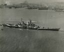
| Date: | 10 23 1945 |
|---|---|
| Description: | Aerial view of U.S.S. Wisconsin (BB-64) in San Francisco Bay. Several boats can be seen in the water near the ship and San Francisco is visible in t... |

| Date: | 1861 |
|---|---|
| Description: | A general map of Pennsylvania, Virginia, New Jersey and Delaware. Insets include maps of New Orleans, Baltimore, St. Louis, Charleston, Savannah, Washingto... |

| Date: | 1862 |
|---|---|
| Description: | This map of the southeastern United States shows cities and towns, rail lines, and geographic features such as rivers, mountains, lakes, and swamps. |

| Date: | 1862 |
|---|---|
| Description: | This map of the southeastern United States shows forts and battlefields, railroads, rivers, and cities and towns. Dates of admission and secession of the s... |

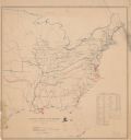
| Date: | 1863 |
|---|---|
| Description: | A general map of the southeastern United States showing Missouri, Kentucky, West Virginia, Virginia, North Carolina, South Carolina, Georgia, Florida, Alab... |
| Date: | |
|---|---|
| Description: | Map of the eastern United States that illustrates the limits of the "loyal states" as of July 1861 in red, the territory controlled by United States forces... |

| Date: | 02 05 1944 |
|---|---|
| Description: | General view of Port Moresby Harbor from road, New Guinea (present day Papua New Guinea). A jeep is on the road on the left. Several soldiers are near a sh... |

| Date: | 1918 |
|---|---|
| Description: | United States government bonds poster in the Fourth Liberty Loan "B" series. "Buy Liberty Bonds. Fourth Liberty Loan." Depicts enemy aircraft bombing New Y... |

| Date: | 1719 |
|---|---|
| Description: | This extremely detailed and ornate map shows the cities, Native American land, mountains, lakes, rivers, and European claims of North America. An inset map... |

| Date: | 1733 |
|---|---|
| Description: | This map of North America shows settlements, rivers, lakes, Native American land, trade winds, and numerous topographical features such as forests and moun... |

| Date: | 1770 |
|---|---|
| Description: | Map of North America from the Great Lakes to the northern portion of South America. It shows cities, Native American land, mountains, swamps, lakes, rivers... |

| Date: | 1781 |
|---|---|
| Description: | Map of the Southeastern part of the British Colonies in North America, Gulf Coast and Caribbean. It illustrates the of the Spanish and English fleets, part... |

| Date: | 1917 |
|---|---|
| Description: | Poster with an illustration of a bird's-eye view of a large bald eagle flying over a convoy of ships, which are headed towards a fire or explosion over the... |

| Date: | 1917 |
|---|---|
| Description: | Poster featuring an illustration of four Marine corpsmen on a beach, with one Marine holding an American flag and another Marine a Marines flag. The other ... |

| Date: | 1918 |
|---|---|
| Description: | Poster depicting enemy aircraft bombing New York, which is in flames. In the foreground, the Statue of Liberty has been attacked and its head has been seve... |

| Date: | 1864 |
|---|---|
| Description: | A map of Sherman's March from Atlanta, Georgia to Goldsboro, North Carolina. |
If you didn't find the material you searched for, our Library Reference Staff can help.
Call our reference desk at 608-264-6535 or email us at: