 Filter: Categories of Wisconsin Historical Images
Filter: Subject of Neighborhoods
Filter: Year of 1800-1899
Filter: Year of 1850-1859
Filter: Categories of Wisconsin Historical Images
Filter: Subject of Neighborhoods
Filter: Year of 1800-1899
Filter: Year of 1850-1859
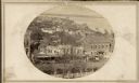
| Date: | 1859 |
|---|---|
| Description: | South Pinckney Street as photographed by Fuller from the Wisconsin State Capitol roof. In the center are several wooden structures dating from Madison's e... |
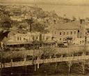
| Date: | 1859 |
|---|---|
| Description: | Madison's Pinckney Street, with the Capitol Park in the foreground and Farwell's octagon house and Lake Monona in the distance. This view has been various... |

| Date: | 1856 |
|---|---|
| Description: | View of Manitowoc from the north side. |

| Date: | 1855 |
|---|---|
| Description: | Pen-and-ink on paper. Includes certifications signed by surveyor and by "John T. Perkins, by his attorney I.A. Lapham." Inscribed and signed certification ... |

| Date: | 1857 |
|---|---|
| Description: | Caption reads: "THE LOTS embraced in the proposed Addition, are situated in the Fourth Ward of the City of Milwaukee, about twenty minutes walk from Spring... |

| Date: | 1858 |
|---|---|
| Description: | Map of Martineau's Addition in the first ward of Milwaukee as well as buildings and location of adjacent additions with landowners names. |

| Date: | 1856 |
|---|---|
| Description: | This map of Woodman's Addition in Mineral Point is pen-and-ink on paper. The map includes certifications signed by John B. Whitelaw (surveyor), Cyrus Woodm... |

| Date: | 1857 |
|---|---|
| Description: | This map shows lot and block numbers, wards, roads, railroads, some landowners’ names, and selected buildings. Lake Michigan, the Milwaukee River, and Glid... |

| Date: | 1857 |
|---|---|
| Description: | This map shows lot and block numbers, wards, roads, railroads, some landowners’ names, and selected buildings. Lake Michigan, the Milwaukee River, and Glid... |
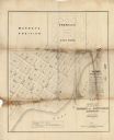
| Date: | 1855 |
|---|---|
| Description: | This map shows plat of town, local streets, numbered blocks and lots, proposed city park, Murray’s addition, and part of Lake Michigan. Also includes a tab... |
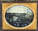
| Date: | 1856 |
|---|---|
| Description: | Half plate ambrotype of an elevated view of Portage City, Wisconsin. The view encompasses a wooden Gothic Revival church and steeple on the right, with a d... |
If you didn't find the material you searched for, our Library Reference Staff can help.
Call our reference desk at 608-264-6535 or email us at: