 Filter: Categories of Wisconsin Historical Images
Filter: Subject of Naval history
Filter: Subject of harbors
Filter: Categories of Wisconsin Historical Images
Filter: Subject of Naval history
Filter: Subject of harbors
| Date: | 12 07 1941 |
|---|---|
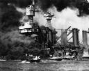
| Description: | Sailors clear the stern of the battleship USS West Virginia in berth F-6 at Pearl Harbor, most likely after it was hit by at least a few of the 7 to... |

| Date: | 12 07 1941 |
|---|---|
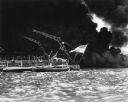
| Description: | The forward magazines of the USS Shaw exploding after a Japanese bomb set the fore aflame as it sat in dock at Pearl Harbor. The midships and stern ... |

| Date: | 12 07 1941 |
|---|---|
| Description: | Capsized USS Oklahoma at Pearl Harbor. The Oklahoma was hit with a large number of Japanese aerial torpedoes which ripped an opening across ... |
| Date: | 12 07 1941 |
|---|---|
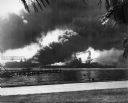
| Description: | The USS Nevada in berth at Pearl Harbor with the USS Shaw burning in the background after its forward deck was hit with a Japanese bomb. |
| Date: | 12 07 1941 |
|---|---|
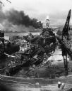
| Description: | The remains of the USS Cassin and the USS Downes floating in front of the USS Pennsylvania in dock at Pearl Harbor. On the left is th... |
| Date: | 12 07 1941 |
|---|---|
| Description: | Sailors in a motor launch attempt a rescue of survivors from the water alongside the sunken battleship USS West Virginia during or shortly after the... |

| Date: | 1913 |
|---|---|
| Description: | Elevated view of shoreline, waterfront buildings, boat-dotted bay and Perry's Victory and International Peace Memorial. The pink-marble, column-shaped monu... |
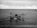
| Date: | |
|---|---|
| Description: | A rear view of a sea plane marked with the number 1700 landing in Hampton Roads Harbor. On the right, another plane can be seen in the water. |

| Date: | 1777 |
|---|---|
| Description: | Map showing the Hudson River in three sections, from New York City up through Lake Champlain, including cities, forts, roads, topographical features, and n... |

| Date: | 1733 |
|---|---|
| Description: | This map of North America shows settlements, rivers, lakes, Native American land, trade winds, and numerous topographical features such as forests and moun... |
If you didn't find the material you searched for, our Library Reference Staff can help.
Call our reference desk at 608-264-6535 or email us at: