 Filter: Categories of Wisconsin Historical Images
Filter: Subject of Mississippi River
Filter: Year of 1800-1899
Filter: Year of 1870-1879
Filter: Categories of Wisconsin Historical Images
Filter: Subject of Mississippi River
Filter: Year of 1800-1899
Filter: Year of 1870-1879

| Date: | 1874 |
|---|---|
| Description: | This map shows lakes, rivers, state, county, and town boundaries, as well as railroads completed, in progress, and contemplated. The map includes a color d... |

| Date: | 1870 |
|---|---|
| Description: | During the War of 1812, the only battle fought in Wisconsin was in Prairie du Chien, in 1814. Made fifty-six years later, this birds eye drawing depicts th... |
| Date: | 1872 |
|---|---|
| Description: | Elevated view of nine rafters wintering at Reed's Landing. At left is Hiram Price, with L.W. Crane beside her. Third is Annie Girdon w... |

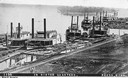
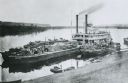
| Date: | 1873 |
|---|---|
| Description: | The harbor, showing the sidewheel packet, "Belle of La Crosse," and the sidewheel ferry "Alex McGregor." Other boats are also seen including two barges loa... |

| Date: | 1872 |
|---|---|
| Description: | The sidewheel packet, Red Wing, in the Mississippi River near Queen's Bluff below Trempealeau, Wisconsin. |
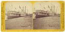
| Date: | 1870 |
|---|---|
| Description: | The sternwheel packet, Red Wing, at a landing on the upper Mississippi River between 1870 and 1882. The sign painted over the wheel reads: "Keokuk N... |

| Date: | 1873 |
|---|---|
| Description: | Bird's-eye map of La Crosse from the Mississippi River. |
| Date: | 1875 |
|---|---|
| Description: | "Iron Bridge across Mississippi" photographed during "The Norwegian Lutheran Synod held at Minneapolis, Minn., 1875," as described in Dahl's 1877 "Catalogu... |

| Date: | 1875 |
|---|---|
| Description: | Aerial view of Alma along Mississippi River, with bluffs along the horizon. |

| Date: | 1870 |
|---|---|
| Description: | Half stereograph of an elevated view from hill showing the confluence of the Mississippi River and the St. Croix River. A man wearing a hat is in the foreg... |
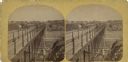
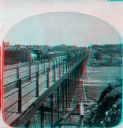
| Date: | 1873 |
|---|---|
| Description: | Stereograph of John Lawler's pile-pontoon railway bridge over both channels of the Mississippi River at Prairie du Chien, and McGregor, Iowa. East draw, 39... |
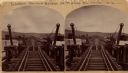
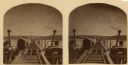
| Date: | 1870 |
|---|---|
| Description: | Stereograph of John Lawler's pile-pontoon railway bridge over the Mississippi River. Three men are standing and sitting on the bridge in the foreground. Bu... |
| Date: | 1875 |
|---|---|
| Description: | View down hill towards "Diamond Jo" steamboat docked on the shoreline of the Mississippi River while goods are being loaded onto the steamboat. |

| Date: | 1878 |
|---|---|
| Description: | Illustrated map of Crawford County. On the bottom right is an inset of a group of people near a train on a railroad track. |
| Date: | 1875 |
|---|---|
| Description: | "Iron Bridge across Mississippi" photographed during "The Norwegian Lutheran Synod held at Minneapolis, Minn., 1875," as described in Dahl's 1877 "Catalogu... |

| Date: | 1870 |
|---|---|
| Description: | Stereograph of John Lawler's pile-pontoon railway bridge over the Mississippi River. |

| Date: | 1870 |
|---|---|
| Description: | A geological survey map of Wisconsin, with hand-colored portions showing the surveys completed from 1873 to 1875. Although the title and legend are in Wel... |

| Date: | 1872 |
|---|---|
| Description: | A series of four hand-colored, geological maps of Wisconsin. Starting from the top of the page, the first map is of a section along the line of the 4th pri... |

| Date: | 1873 |
|---|---|
| Description: | A hand-colored, geological map of the Fox and Wisconsin rivers’ water path from the Mississippi River to the Great Lakes. The map also shows those railroad... |
If you didn't find the material you searched for, our Library Reference Staff can help.
Call our reference desk at 608-264-6535 or email us at:
